Jirisan Baraebong Royal Azalea Hike


Jirisan Baraebong Royal Azalea Hik-15

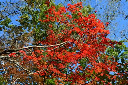
A couple weekends ago, I finally was able to go on the Baraebong Peak Royal Azalea hike in Jirisan National Park. I read about this hike last year, but wasn’t able to do the hike. Since this year is my last spring in Korea, I knew I really needed to do this, because the pictures I’ve seen of this hike are absolutely beautiful. Luckily for me, in my online searches about this hike, I discovered the Seoul Meetup group that was planning to do this hike, and I eagerly signed up.

Jirisan Baraebong Royal Azalea Hik-1

After signing up, I realized that the hike the meetup group does, is only a short version of the hike. The true hike is the Jeongnyeonchi Hill Baraebong Peak Course. It starts at the Jeongnyeonchi service area and ends at Undong village. That hike is about 12.6 kilometers, and most of it traverses a ridgeline and passes through numerous passes that are covered in colorful azaleas. Unlike most hikes I have done in Korea, that hike has very little in the way of steep inclines, and the one steep decline is at the end of the hike.

Jirisan Baraebong Royal Azalea Hik-2

Jirisan Baraebong Royal Azalea Hik-8

The shorter hike we did started at Undong village and continued up the hill to Baraebong Peak with a diversion to Pallangchi Pass, with a return to Undong village. The hike we did was around 8 kilometers. This hike was also the steepest part of the whole hike. The hike starts at Undong village and ascends sharply to Baraebong Samgeori. The altitude gain on this hike was over 400 meters in a brief period of time.

Jirisan Baraebong Royal Azalea Hik-3

Jirisan Baraebong Royal Azalea Hik-9

I was definitely feeling the hike in my legs. It was in the middle of the day, and the sun was bright and overhead. There was only minimal shade on this hike, but I took advantage of it whenever I could. Surprisingly, all of these spring hikes I’ve done this year have felt easier than the fall hikes I did. I’ve actually been passing Korean hikers on the paths. My knees certainly feel better. I would like to think that I am simply fitter now than I was in the fall. Or maybe I am just missing all the fitter Korean hikers. But the more likely answer is that I’ve been hiking on easier paths. Sure, the trails are steep, but the trails are wide and surprisingly well-benched. At times I even felt like I was hiking in New Zealand.

Jirisan Baraebong Royal Azalea Hik-4

Jirisan Baraebong Royal Azalea Hik-10

This hike is very popular, particularly this time of the year. There were scores of tour buses at Undong village, and even more groups hiking in from Jeongnyeonchi pass. This popularity is probably why the trail is so well benched, but it also means it is VERY crowded.

Jirisan Baraebong Royal Azalea Hik-12

Jirisan Baraebong Royal Azalea Hik-13

For most of the trail, that is not really that big of a deal, but parts of the trail around Pallangchi pass are rather narrow, so there were times a long line formed on the trail. Sure that make the walking slower, but this also allowed a greater opportunity to take in the beautiful azaleas.

Jirisan Baraebong Royal Azalea Hik-5

Jirisan Baraebong Royal Azalea Hik-14

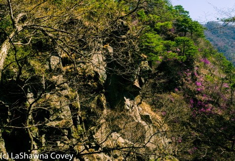
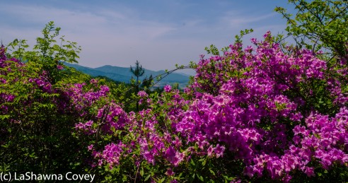
The azaleas at lower altitudes already passed their blooming season, but as I ascended in altitude, there were more and more azaleas on the path.

Jirisan Baraebong Royal Azalea Hik-19

Jirisan Baraebong Royal Azalea Hik-16

Once I reached Baraebong Samegori, I ascended to the top of the peak. Most of the trail was relatively flat, but the last 250 meters before hitting the peak were so steep, but the view from the top was worth it. I could see all the surrounding mountains, and I could see further down the trail, where the patches of azaleas were abundant around Pallangchi pass. I had plenty of time before having to return to the bus, so it was a pretty easy walk out to the pass.

Jirisan Baraebong Royal Azalea Hik-6

Pallangchi pass was definitely worth the walk. All around the areas were thousands of bright purple azalea flowers. The hills were fields of pink, and I had never seen anything quite like it.

Jirisan Baraebong Royal Azalea Hik-7

Independent travel for this hike is not exceptionally easy or cheap, but it is doable. The quickest way is probably to take a train from Yongsan to Namwon station, and then a taxi to Jeongnyeonchi service area. At the end of the hike at Undong village, there were plenty of taxis waiting, to get a ride back to Namwon station. There really aren’t any buses in the area, so you really have to take a taxi or be part of a tour group.

Jirisan Baraebong Royal Azalea Hik-11

If you have the opportunity to do this hike, I highly recommend it. I have never run into the opportunity to do a hike that afforded an opportunity to see so many wild, colorful azaleas in one place. Parts of the hills were all pink, and even the parts that aren’t, offer up so many beautiful views of the surrounding Jirisan National Park.

Jirisan Baraebong Royal Azalea Hik-17

Jirisan Baraebong Royal Azalea Hik-18

A couple of tips for this hike. If possible, I would highly recommend you start this hike early, particularly if you are doing the full 12.6 kilometers. This will hopefully allow you to get out in front of the bulk of the Koren hiking groups, though there will be the really dedicated hikers out there. Definitely take plenty of water, sunscreen, a hat and sunglasses, because the bulk of the hike is very much exposed, and the sun will beat down on your head during a sunny and bright day.


Hwagae Cherry Blossoms and Buril Falls

Hwage Cherry Blossoms and Buril Falls-15

My favorite part of Korean spring is the blooming of the cherry blossoms. I adore the gorgeous pink and white blooms that fill the cities and countryside for such a brief time. While the cherry blossoms are a delicate beauty, they are also a very ephemeral beauty.  Cherry blossom season only lasts about seven to ten days, so it’s nearly impossible to see all the places where cherry blossoms bloom in one spring season.

Hwage Cherry Blossoms and Buril Falls-1

Hwage Cherry Blossoms and Buril Falls-6

Last year, I confined most of my cherry blossom hunting to around Seoul, but this year I pushed farther afield.  I decided to make a trek down to Hwagae. I went the week after their official cherry blossom festival, hoping to avoid the hordes of crowds I read about. Of course the danger of going the week after the festival, is that I missed peak blossoms, but there were still enough to enjoy plenty of color. I also took the advantage to combine a few sightseeing places into one trip. I was able to see the Hwagae cherry blossoms, the Ssanggyesa Temple and Buril Falls in Jirisan National Park in one long day trip.

Hwage Cherry Blossoms and Buril Falls-2

Hwagae is fairly easy to reach by bus from the Seoul Nambu Bus Terminal. There are numerous buses per day, and it takes about three and a half hours (traffic depending) to reach Hwagae.  I wished I had taken the first bus out of Seoul, which would have given me an extra hour and a half in Hwagae, but I was able to see everything I wanted to see (albeit not at the most relaxed pace).

Hwage Cherry Blossoms and Buril Falls-3

Hwagae is a tremendous opportunity to see a bulk of the cherry blossoms. There is an approximately four kilometer stretch of road from the town of Hwagae to Ssanggyesa Temple, and most of the road is lined with gorgeous cherry blossom trees on both sides. It is a very easy walk on flat road by a river (just pay attention to the traffic, though it was often so backed up that I was moving faster than some of the cars), and it is a great opportunity to get your cherry blossom fix. The opportunity for beautiful nature viewing and nature photography are abundant.

Hwage Cherry Blossoms and Buril Falls-4

Hwage Cherry Blossoms and Buril Falls-5

The end of this road is Ssanggyesa Temple (follow the signs), which is a small Buddhist temple complex originating in the year 723, but was rebuilt in 1632. I didn’t spend an extraordinary time at the temple, because I was pressed for time, but it was pretty nonetheless.

Hwage Cherry Blossoms and Buril Falls-10

Hwage Cherry Blossoms and Buril Falls-14

The last sightseeing part of my day was Buril Falls, which is on the edge of Jirisan National Park. The hike from Ssanggyesa Temple to Buril Falls is only about 2.4 kilometers. The hike is considered an “easy” hike, and I suppose it is by Korean standards. Most of the hike to the falls is uphill, sometimes over the uneven terrain I am so used to, but the most strenuous part of the journey is the first 500  meters from Ssanggyesa Temple and the 100 meters up very steep stairs on the return trip from Buril Falls (your knees will probably feel both the uphill and the downhill of that climb). Then the uphill levels out a bit and becomes easier and it took an hour and twenty minutes to reach the falls, and an hour to return, less if you are a faster walker. The trail ends at Buril Falls, which is considered one of the 10 scenic beauties of Jirisan National Park.

Hwage Cherry Blossoms and Buril Falls-12

Hwage Cherry Blossoms and Buril Falls-11

Retracing my steps was fairly quick, and soon enough, I was back to the temple and cherry blossom road to hike back to Hwagae. It was only a one hour walk back to town, and the sun was approaching sunset, giving the cherry blossom trees a beautiful, soft, pink glow.

Hwage Cherry Blossoms and Buril Falls-9

Hwage Cherry Blossoms and Buril Falls-16

I was hoping to take the direct bus back to Seoul, but that wasn’t happening. There were large groups of people waiting at the bus stop and all the buses back to Seoul were sold out for the night. But all was not lost. I caught a local bus to the town of Gurye (about 20 kilometers away) and then took a taxi to the Gurye-gu KTX station to catch a train back to Seoul. Of course all seats on the train were sold out, as it often happens on the Sunday evening trains back to Seoul. Thankfully for me, you don’t need a reserved seat to ride the train. You just need to be willing to stand for the few hours to get back into Seoul.

Hwage Cherry Blossoms and Buril Falls-8


Hwage Cherry Blossoms and Buril Falls-7

I highly recommend Hwagae as a lovely day trip from Seoul. Even though the crowds will be thick that time of year, it is definitely worth your while to go during cherry blossom season. There are few places you can see so many cherry blossoms in one area, and there are so many other sites to visit at the same time.


Jirisan National Park- Piagol Valley Autumn Hike

Piagol Valley colorful foliage river title picture

I did a lot of reading to plan my autumn hiking season in Korea, and one of the places I kept coming across was the Piagol Valley in Jirisan National Park. This quote was frequently sited on articles about this valley, “People who have not seen the red-tinted leaves in Piagol dare not say they know red-tinted leaves.”- Jo Shik, a Confucian scholar of the Joseon Dynasty. A popular autumn leaves festival is held in the Piagol Valley around peak foliage time (supposedly 24 October 2013).

Piagol Valley orange river reflection

Piagol Valley branches with red leaves

Piagol Valley bright red, orange and yellow leaves

So as you can imagine, I had grand visions of awe inspiring beauty for this hike. I imagined the entire trail tinted red, and looking through my pictures, I am reminded how beautiful this hike can be, and how many shades of red and orange percolate through the valley and glow in the bright sunlight. However, I also look back on this hike as exemplifying two other concepts: the gap between expectation and reality, and knowing your own limits.

Piagol Valley shaded valley view

Piagol Valley river pool with red foliage

Piagol Valley river waterfall with red and yellow leaves

Last Sunday when I hiked this, the day dawned very early for me, since my train left from Yongsan Station at 0520. It was a three hour train ride to Gurye-gu Station. I could have taken a bus from Seoul to Gurye, but aside from my preference for trains, I was actually able to start hiking sooner than if I had taken a bus. I knew there were local buses that went from Gurye to the Piagol Valley trailhead, but none of them originated from the train station to my knowledge. So to save time, I elected to take a taxi from the train station to the trailhead, which only cost me 30,000 won (negotiated fare, not meter fare), and it was a roughly 30-40 minute ride. It was still pretty early in the morning when I started hiking, so there weren’t TOO many hiking groups out on the trail.

Piagol Valley bridge with red and orange leaves

Piagol Valley orange and green trees

Piagol Valley red and green leaves

I had planned in advance to only hike to the Piagol Shelter and back, and not push all the way up to the Piagol Samgeori (forked road). While it was only two kilometers from the shelter to the pass (1.2 miles), I could tell from online maps it was pretty steep, as the estimated travel time was two hours one way. This was confirmed for me when I looked at the map at the trailhead, and it had that portion of the trail at a 32% gradient. I remembered, and my legs remembered, the Ulsan Bawi hike which had nearly the same level of steepness, how long it took me, and how much my body ached afterward. Combine that with the distance being twice the distance of Ulsan Bawi, and it reinforced my desire to just to go the Piagol Shelter. I knew my limits of my body, the limits of my hiking speed, and the limits of the return trip to Seoul (since I already had a train ticket booked), and elected to only do the eight kilometer round trip hike to the shelter and back. That hike was only projected to take four hours round trip and the gradient was described as only 6% by the map, so I thought it would be a pleasant and easy hike. However, in my opinion, that map spoke lies. Maybe the AVERAGE gradient of that hike was only 6%, but there were plenty of times throughout that hike that it was much, much steeper.

Piagol Valley orange and yellow leaves river

Piagol Valley shelter

Piagol Valley colorful leaf trees and river

Parts of this trail were very well-maintained that reminded me of American hiking trails. Other parts of this trail were supremely uneven with big rocks substituting for an actual path. If I didn’t actually know what some Korean hiking trails looked like, I might think I was lost in the middle of the woods. But I would never get actually lost, because I was never actually alone out there. This hiking trail is very popular, and I saw dozens of hiking groups. In fact most of them skillfully and quickly passed me as I trudged along the trail, carefully picking my way from one uneven rock to another to avoid falling or spraining my ankles. I forgot to bring my walking sticks (AGAIN!) and my body (particularly my thighs and my knees) definitely felt it by the end.

Piagol Valley swing bridge with colorful leaves

Piagol Valley river pool and red leaves

Piagol Valley red and orange overhead foliage

This brings up the gap between my expectation of this hike and the reality of this hike. I thought this hike would be easier than it was, and I admit to feeling a bit dispirited by the end, and supremely grateful when I completed the hike. I kept thinking that what do Koreans have against even, well-maintained trails. Maybe it’s part of the fun to not only enjoy a colorful view, but also to lightly hop from one rock to another.

Piagol Valley colorful rocky river

Piagol Valley red, orange and green leaves

Piagol Valley orange and yellow overhead foliage

In any case, while I don’t regret going on this hike, if I had known all of this in advance, I might not have done the hike. There are very beautiful views on this hike, but I didn’t see anything so unique that I haven’t seen on other Korean hiking trails. Though looking back at all these pictures, I do marvel at the colorful beauty I saw. So honestly, if I was more fleet of foot and didn’t stumble on uneven trails, I probably would have enjoyed it more. My opinion of this hike is colored by the fact that I can be a graceless klutz at times.

Piagol Valley small waterfall and red leaves

Piagol Valley red orange leaves

Getting to and from Gurye is pretty easy. Like I said before, you can take a train or a bus. Both of them travel from Seoul to Gurye on a regular basis. If you take a bus to Gurye, you can easily transfer to a local bus to Piagol (approximately one per hour) directly from the bus station. Or you can easily take a taxi to the trailhead. Getting back from Gurye was a bit more painful, because all the direct trains were full and I ended up having to make some transfers, and what is a three hour direct KTX train between the two cities, became a six hour journey over slower trains. So if you take the train back, make sure you book your train ticket well in advance, particularly on popular weekends, like the height of autumn and spring.