

If you want to visit Argentina Patagonia, there are two main places to base yourself (though by no means the only places)- El Calafate and El Chalten. El Calafate is where you go if you want to enjoy glaciers, big lakes, estancias. El Chalten is where you go with you really want to get your hike on, and is about a three hour drive north from El Calafate. There are many hikes that are easily accessible from El Chalten, plus a variety of other outdoor activities, such as mountain climbing or river kayaking.
I did extensive research when prepping for this part of the trip. I knew I wanted to enjoy some hiking, BUT I also knew my own physical limits, and wanted to take that into account. I consider myself to be of moderate fitness, but I can struggle on long uphill hikes, especially ones that are already at elevation.

The two most celebrated hikes from El Chalten are the Laguna Torre hike and Laguna de los Tres hike. I read a lot of blog posts about individual experiences with hikes, trying to gauge how I would respond. I came to the conclusion that Laguna Torre is considered the “easier” of the two hikes, so I decided to hike that one first. The nice thing about most of the hikes in the area are they are easily accessible from the town of El Chalten. In fact, the trailhead for the Laguna Torre hike was only about 500 meters from my hotel.

I started out fairly early in the day (around 0730), because my research suggested that the trails get very crowded by 0800. Maybe that is true for the height of the summer season, but I was there in November, so it didn’t start getting crowded until mid-day when I was ready to hike back.
The Laguna Torre hike is an out and back hike, which are not my favorite type of hikes, and the combined mileage is around 11 miles, though I found differing distances listed in the different accounts I read. I knew based on my reading that the first three kilometers were the most strenuous of the hike, since it is mostly uphill. That is definitely true. The path can be flat and easy at times, but it also is the most uneven and precarious in the first part of the hike, and as I was ascending, I could see that I was going to struggle a bit with part of the trail on my return, just because of loose stones or dirt or other things that can make clumsy people trip and fall.
I was huffing and puffing on the first part of the hike, and inwardly wondering if this was going to be worth it. But I also enjoyed the mostly blissful solitude, since I saw very few people on this part of the trail. I was passed by two different pairs, but they quickly got ahead of me, and I felt like I had the whole trail to myself.

Those strenuous for me three kilometers were worth it when I arrived at the Mirador Laguna Torre, a viewpoint that gave me my first taste of the mountains, especially Cerro Torre off in the distance and the forest spread out before me. It was an inspiring sight to see, and the weather was perfect- sunny and clear. After taking it all in for several minutes, and wanting to stay ahead of the groups that were starting to catch up to me, I continued on. After climbing up for the first three kilometers of the hike, the trail after the viewpoint descends for about another kilometer, which I welcomed, though mindful that I would have to ascend the trail on the way back.

After the fourth kilometer, the trail gets markedly easier. It is pretty flat by this point, and easy to navigate. For the most part, the trail is pretty level, which means I could enjoy the view around me, and didn’t have to keep staring at the ground hoping I didn’t trip over something. That allowed me to really drink in the mountains as I was getting closer to them, and the surrounding forest.
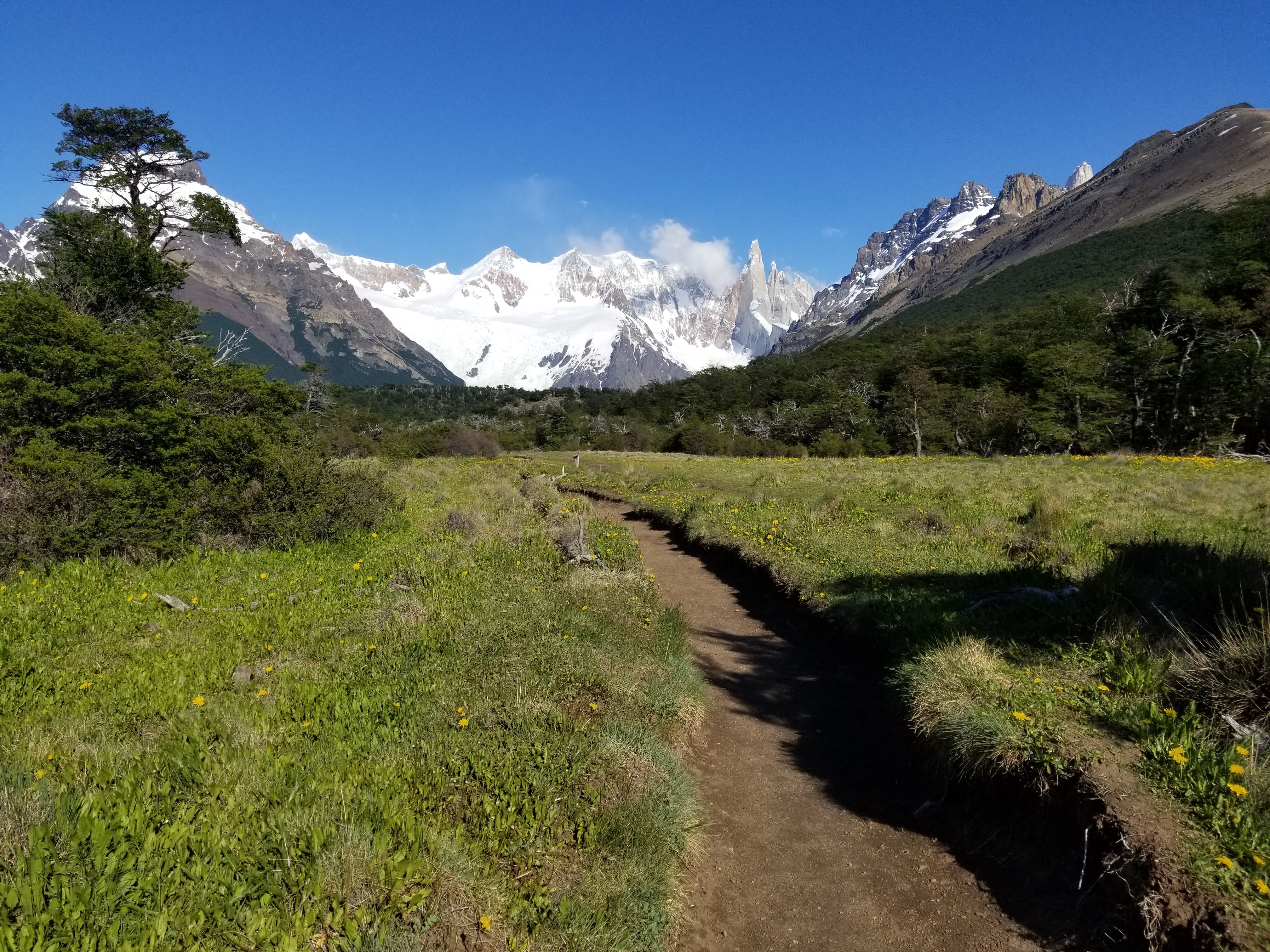
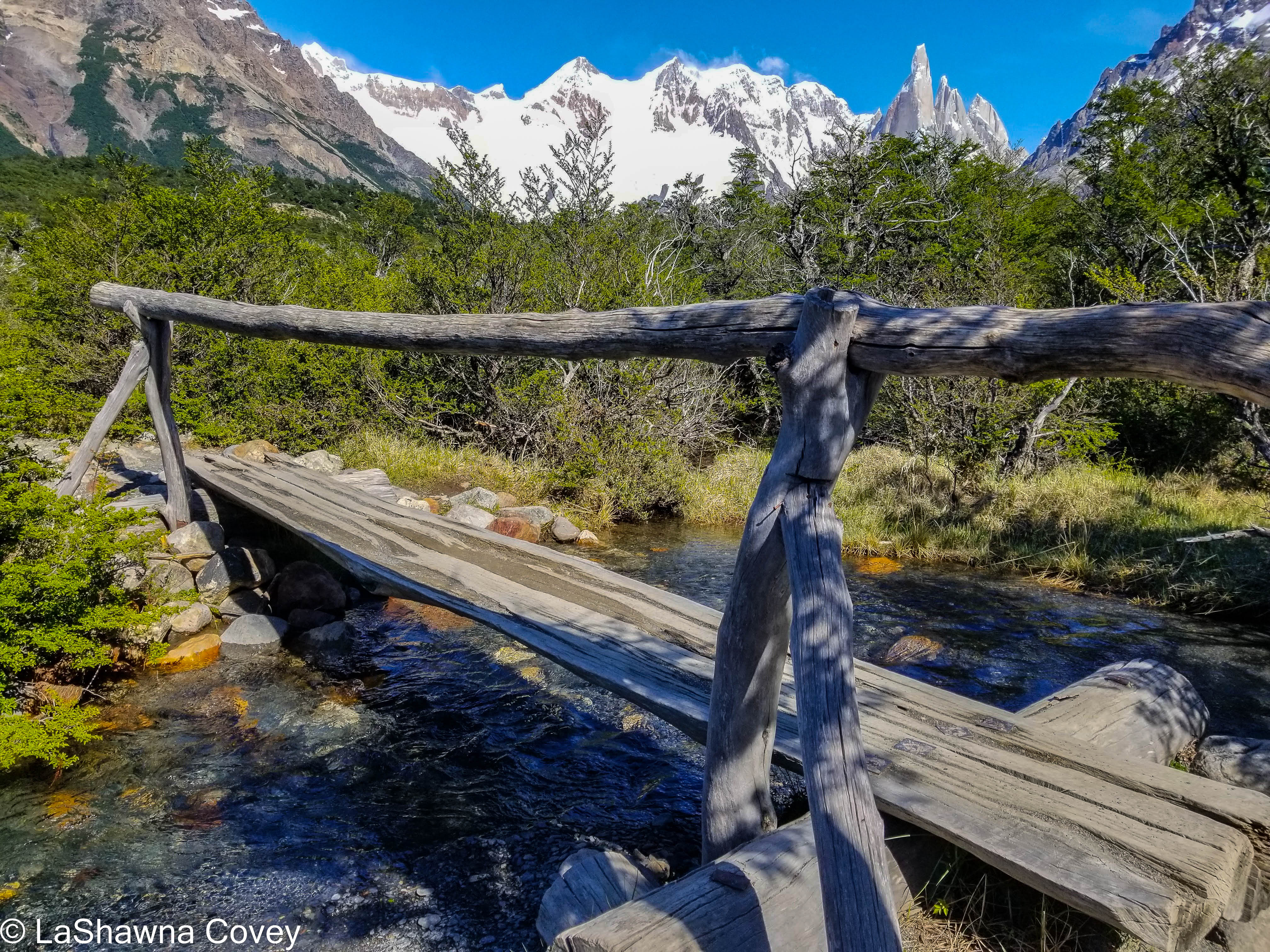
The trail is fairly easy to follow most of the time, though sometimes when going through rock fields, you have to keep an eye on what is actually the trail. But it is near impossible to get lost on this trail, since there really aren’t other social trails drifting off any length of distance. I crossed a small creek, and I knew I was getting close. A very nice thing about this trail, is that it is clearly marked with signs every kilometer. It tells you what kilometer you are on, and how many kilometers in total to your destination (e.g. Kilometer 5 of 9). At the beginning, I found it somewhat demoralizing, only because I thought I was much farther on the trail, only to realize that I had only walked two kilometers of nine. But once the trail flattened out and became easier, the kilometer markings seemed to fly by, and it was heartening to see me getting closer.

The final part of the hike is a short hike up the rocks until you are overlooking Laguna Torre. That view makes any sort of huffing and puffing worth it. I knew this lake is not a brilliant blue like Laguna de Los Tres, but the spiky mountains look close enough to touch, and the lake had a wide variety of icebergs floating from the glacier by the lake. Truthfully I thought was even better than what I was expecting.
When I first arrived at the lake, there weren’t many people already there. I had only been passed a small number of times, much to my surprise. So at first I felt like I almost had the lake to myself. I just sat by the lake taking it all in. It was only about midday, and the only thing I had left was to walk back, so I was in no hurry to finish my lunch. Of course the longer I stayed there, the more and more people started arriving, especially those large walking groups.

Eventually I decided I had my fill of the view and was ready to return before the trail became clogged with hikers. By this time, my body was feeling the walk, and I knew I still had nine kilometers to go (a bit more when factoring in the walk from the trailhead back to my hotel). Thankfully the first five of those kilometers were the flat and easy part of the trail. Those parts flew by. Things started to slow down for me when I hit the fourth kilometer and I had the slow slog back up to the viewpoint.
After resting a bit, I finished the final three kilometers, but it was those three that were the hardest. This is the part of the trail I was getting passed left and right by spry, fit hikers as I was carefully placing my feet and maneuvering through uneven terrain, and by that point, I was tired and over the hike. But thankfully enough I found myself at the road without falling or twisting an ankle. From there, it was a slow walk back to my hotel where I could indulge in a welcome shower and a nap.

Overall, I am glad I did the hike, though part of me was cursing the hike as I was doing it. If I of moderate fitness could make it without my feet falling off, so can most people. If you can make it through the first three kilometers (and they aren’t THAT strenuous in the grand scheme of thins, but if you aren’t pretty fit, you will feel the uphill and the uneven terrain), the rest of it is a piece of cake. And of course, the views are worth it. Even though I have spent a fair amount of time in the mountains, the mountains of Patagonia look so different from the Cascade Mountains I am used to, that the view was an absolute delight.
