Enjoying the Waterfalls and Glaciers of Skaftafell National Park

Skaftafell National Park-4

As I’ve talked about in previous blog posts, South Iceland is just filled with beautiful nature of an incredibly diverse sort. It is quite amazing that for an area that really isn’t that big, you can find nearly so many different ecosystems .

On one of many days in South Iceland, I budgeted a full day for Skaftafell National Park, though I didn’t think we would need the entire day. Skaftafell National Park is the southern part of the larger Vatnajokull National Park.

The park itself is rather big, but for most day trippers, the bulk of the sites are within a couple miles walk of the visitor’s center. The two biggest attractions for visitors are Svartifoss and Skaftafellsjokull. Both of them are reached by well-maintained trails with under an hour of walking, but there are also more longer, more difficult trails for those who want to venture deeper into the park.

Skaftafell National Park-11

I knew Skaftafell National Park is a very popular destination, with some estimates of 500,000 visitors per year, making it one of the top attractions in the country. So even though we were visiting during the shoulder season, and not high tourist season, I wanted to get to the park early so we could beat a large part of the crowds.

Skaftafell National Park-6

Skaftafell National Park is easily reached off Ring Road 1, with a well marked sign. Like all of the other national parks and attractions in Iceland, admission to the park is free. That is one of the very nice things about visiting Iceland. I am so used to America charging admission to a good number of their parks and other beautiful nature sights. However, there is one thing about Skaftafell that is uncommon in the rest of the country: they charge for parking. I only encountered this in two different sights in Iceland: Skaftafell National Park and Selijalandsfoss. Having gotten so used to everything being free, this took me aback a bit. But the parking charge is about six dollars for 24 hours. And considering how this park is probably feeling the weight of the tourist crush, I can’t say I blame them for charging for parking.

Skaftafell National Park-2

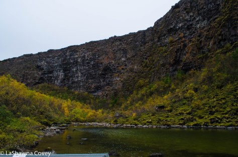
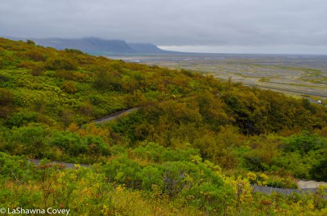
Since we got there early, the parking lot wasn’t too full, and there weren’t that many tour buses. After a brief overview of our two planned trails at the visitor center map, we set off to see Svartifoss first. I knew that was the MOST popular sight, so I wanted to see it before the crowds set off. Shortly after we set off on our 1.8 kilometer hike to the waterfall, I realized we had been had by my guide book. My guide book had designated the trail as “easy”, so I figured the trail would be mostly flat and well maintained. Well…I got half of that right. The trail is very well maintained, with most of it cement, and the a good chunk of any uneven ground is covered in plastic coverings. But flat? That’s a laugh. The trail is nearly all uphill for the route to the waterfall. And when I mean uphill, I’m not talking a gentle incline, but rather steep in more than one part. It was quite the puffer at times, and I took advantage of the some of viewpoints of other waterfalls, or viewpoints of the surrounding countryside, to catch my breath.

Skaftafell National Park-1

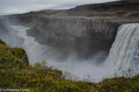
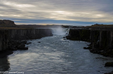
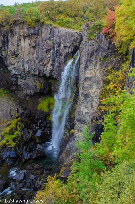
Eventually, we saw a nice waterfall off in the distance, and wondered if that was Svartifoss. Even though it had basalt columns like was described in my guide book, I dismissed it initially, because the waterfall looked too small to be a large tourist attraction. But once we got closer to the waterfall, I could see that yes, in fact it was Svartifoss, but thankfully it looked more majestic up close. You can view the waterfall from a bit of a distance at the bridge that crosses the river, or you can take a short trail to the base of the waterfall for a very nice view.

Skaftafell National Park-3

The waterfall looks really nice up close and personal, and the basalt columns are interesting to look at, with the combination of basalt vertical columns and hexagons, formed by differing sorts of volcanic activity.

Skaftafell National Park-5

After admiring the waterfall for a bit, we continued on up the trail out of the valley. You can turn back and take the trail down the way you came up, though it really isn’t encouraged. Due to the large volume of tourists, the park requests you take another trail back, so as to control the flow of people traffic. The trail back was nice. It wasn’t anything overwhelmingly beautiful, but it provided some nice views of the surrounding countryside. We could also see the hordes of tourists making their way up the hill to visit the falls and we were glad to miss the tourist crush. Even more so, when we got back to the visitor center and saw the lines of buses parked in the lot.

Skaftafell National Park-8

For our next hike, we walked out to Skaftafellsjokull, which is a glacier within the bounds of the national park. My guide book promised an easy 1.8 kilometer walk to the glacier, and this time, they were right on the money. The trail is flat and you can see the glacier off in the distance when you start, growing bigger as you approach it.

Skaftafell National Park-9

This glacier is like a junior version of Fjallsarlon. The glacier is not that big, and like he rest of Iceland’s glaciers, it is retreating, and leaving behind a growing glacier lagoon in its wake. Due to the deep looking, fast moving glacier river that comes from the glacier, you can’t just walk up to the glacier, but rather view it from a short distance. It’s not the most impressive glacier in South Iceland, but it is still nice to stop and marvel at the sheer accessibility of Iceland’s glaciers, a fact that is liable to change in the coming years through glacier retreat due to climate change.

Skaftafell National Park-10

Even though I had budgeted the entire day for Skaftafell, it took really only about a half a day. So we headed back to the hotel to relax in our nice, warm hotel room and plan for further adventures. Skaftafell is super easy to reach in South Iceland. Just know that is a popular tourist attraction, so plan accordingly.

Waterfalls and Other Natural Wonders in Jokulsargljufur National Park

Vatnajokull National Park-9

Staying around the Myvatn area not only has its own local pleasures (detailed in my previous two geothermal posts), but it also serves as a great base for seeing sights further afield. One of the ones I most anticipated visiting was Vatnajokull National Park. The park itself is rather large, and the result of merging two previously separated parks- Jokulsargljufur and Skaftafell National Parks. Jokulsargljufur is in the north east of the Myvatn area, and Skfaftafell is in the south, both accessed by different parts of Ring Road 1.

The highlight of Jokulsargljufur, and one of the highlights to any Iceland trip (especially if you are a waterfall aficionado like me), is Dettifoss. While Dettifoss is not the tallest waterfall in Iceland (that would be Glymur, which is located off the head of Hvalfjordur in the west, north of Reykjavik), it is considered to be the most powerful in terms of water volume. It has been featured in numerous movies, and I just really wanted to see it. I had hoped to see it on my first trip to Iceland, but the snow reared its ugly head again. Sure, the main road to Dettifoss is paved, but it is 24km from the Ring Road to the parking lot, and that is a lot of road to plow in the winter, with fewer visitors to justify it. Though again, that was in 2011, and with the increasing number of winter tourism, hopefully the government is keeping the roads to the more popular attractions plowed.

Vatnajokull National Park-1

My mother and I got started early on our day trip to Jokulsargljufur for a couple reasons. First, we wanted to beat the crowds to Dettifoss and see the waterfall without a lot of people around. Second, Dettifoss was not our only stop in the park. There is lots more to see and do in the area, and I wanted to drive up the park road to the northern edge around Asbyrgi in the north and do a lot of short, but scenic walks along the way.

Like I said, Dettifoss is easily reached from Ring Road 1, and it is about a 20 minute drive east of Myvatn. There are actually two roads you can access the falls, one on the west side of the falls and one on the east side of the falls. The western access point is the more popular site and is called Route 862. This route is paved all the way to the Dettifoss parking lot. I’ll talk about the eastern access in a bit, because that is a story in and of itself.

Vatnajokull National Park-2

We did get there early, and there were only a handful of cars already there, which gave us great relief. Based on the sheer size of the parking lot, along with the numerous tour bus parking spots, it is obvious how popular it is. I can only imagine the hordes of crowds in the tourist peak summer.

From the parking lot, it is about an 800 meter walk to the falls viewing site, but you can see the spray rising in the distance. The walk to the falls is easy and flat and well marked. We went straight to the falls first to get our first view of Dettifoss and it did not disappoint. The western side has more dedicated viewing platforms, but it also has more fencing to protect visitors. Even so, you are still pretty close to the falls. The sheer volume of water spilling over the falls is astounding to behold, and the sound is thunderous. We could just stand there and take it all in. The water is a milky white, because it is being fed by a glacier upstream.

Vatnajokull National Park-3

Dettifoss may be the biggest and most famous waterfall in Jokulsargljufur, but there are others. One of them is called Selfoss, and is located about 1 kilometer north of Dettifoss. Again, the path is well marked, flat and easy to follow. After we had our fill of Dettifoss, we headed out to that falls. Selfoss is a much smaller, though still pretty, horseshoe shaped falls. Unlike Dettifoss, the best view of the falls (at least on the western side) is from a distance a few hundred meters away. Even though you can get close to the falls  near the head, just the configuration of the land and the large width of the pool feeding the falls prevents any better view of the falls close in.

Vatnajokull National Park-6

Vatnajokull National Park-7

By the time we got back to our car, the tourists were starting to come more en mass, so we smirked at how we beat most of the crowds. Our intention was to continue driving north on Route 862, with our next planned stop around Vesturdalur, which is a nice camp site halfway through the park that was supposed to have some beautiful rock formations. However, that was not to be. Most of Route 862 north of Dettifoss to Asbyrgi is gravel, but the government is making steady progress paving the whole way. So much progress, that they were paving the road at the time of our visit, and had blocked it off to the rest of traffic. So we were forced to turn around.

At that point, it became a debate about how best to see the rest of the park. My first instinct was to drive ALL the way around to the north, but that would have taken at least an hour (probably more), even though the roads itself would be paved. OR we could take the alternate route to Asbyrgi, which is the eastern route called Route 864. I had been hesitant to take it, because our guide book emphasized how rocky and rutted the gravel road was. But considering it said the same thing about the roads in the Westfjords and I felt it overstated the road conditions, we figured we would at least see how bad the road was, because using the eastern route could save on a lot of useless time driving.

Vatnajokull National Park-4

So even though I had not intended to use the eastern route, now I found myself navigating the road. However, I figured there was an upside to taking the eastern route, and that was visiting the eastern side of Dettifoss. More on that in a bit, because we first had to get there, and at some point in the 24 kilometer drive to the Dettifoss parking lot, I almost gave up and turned around. While I have not driven every road in Iceland, I can say with confidence that Route 864 from the Ring Road north to the eastern Dettifoss parking lot, is the worst road I drove in Iceland. I could barely get above 10 kph, because the ruts and potholes were so frequent. Now granted, this would not be a problem for all vehicles. We got passed by numerous larger, SUVs who barrelled by us with their bigger tires, 4WD, and higher clearance, while we putted along in our tiny, low clearance car that shook with every rut and pothole we encountered. So as tempted as I was to just chuck it all in at certain points, I kept going. Part of it was out of sheer stubbornness, since we had started this adventure. Part of it was now out of a desire to see the eastern side of Dettifoss and Asybyrgi. And part of it was because I did not want to drive back on that road if I didn’t have to.

We both breathed a sigh of relief when we finally arrived at the parking lot. By this point, it was midday, so the parking lot was full of cars, but not near as many cars as on the western side. Since Route 864 is so bad, it discourages many tourists, and honestly, it is for the better.

Vatnajokull National Park-5

The path from the parking lot to Dettifoss is about the same distance as on the western side, but it is mainly downhill (so it will be uphill on the return to your car). The path is not as well maintained, and when you get closer to the falls, it is basically just walking over large rocks. The views from the eastern side are different, and provide a more expansive view of the surrounding canyon.

But the BEST part of visiting the eastern side of Dettifoss, the main reason I would recommend it if you have the time and patience to drive the horrible road, and the main reason why I think the government allows the road to stay horrible, is because you can literally stand on the edge of the waterfall. I mean, there is NOTHING between you and the falls. No fence, nothing. You could easily just stick your hand in the water and feel its power. Of course, you could also do something reckless and stupid that could ensure you fall to your death, but I would like to think anyone who would drive to the eastern side of the falls, has enough common sense and protective instincts to respect Dettifoss and not do anything stupid.

Vatnajokull National Park-10

The view is so amazing, just because you are so close to the falls and can REALLY feel its thundering power, that I didn’t want to leave. But leave we must, so after getting back to our car, we had a decision to make. Do we take the devil we know- the potholed road from hell back to the Ring Road- or the devil we didn’t- the rest of Route 864 north. We decided we would at least try  the road north, figuring we could turn around at any point if it became too hellish.

Vatnajokull National Park-11

And wouldn’t you know it, but the road north of Dettifoss is MUCH better . I mean, light years better. Sure there are still some potholes, but overall, it is better maintained and graded. We could even pick up some speed as we headed north. There is no access to Vesturdalur from the eastern side, but there are other views to be had.

Vatnajokull National Park-8

We saw our third waterfall of the day called Hafragilsfoss. It is located a short ways downstream from Dettifoss, and can actually be reached by a trail from the Dettifoss parking lot. But if you don’t want to walk to it, there is a marked car park that overlooks the falls. You aren’t particularly close to the falls from the car park viewpoint, but it is a very pretty, expansive view of the falls and the canyon.

Vatnajokull National Park-12

After Hafragilsfoss, we pretty much sped up Route 864 until we hit the main road of Route 85. Even though driving up the eastern road to Dettifoss took a lot out of me mentally (yeah, I know), we still wanted to see Asbyrgi.

Vatnajokull National Park-13Vatnajokull National Park-14

Asbyrgi is the northern edge of Jokulsargljufur, and it is an enclosed canyon that is filled to the brim with verdant foliage. You can easily drive in the canyon on a paved road from the visitor’s center. We took the road all the way to the end (only 3.5 kilometers) to the car park. From the car park, there are a variety of short hikes. We elected to take the trail to Botnstjorn, which ends at a scenic duck pond at the head of the Asbyrgi canyon.

Vatnajokull National Park-16Vatnajokull National Park-17Vatnajokull National Park-15

It was nice to see that a lot of foliage was turning colors for fall, and the whole surroundings were just peaceful. At this point, we had our fill of the canyon for the day and headed back to the main road, with only a short stop to photograph Eyjan, which is this odd and large rock outcropping in the middle of the canyon.

Vatnajokull National Park-19

I highly recommend a full day trip to Jokulsargljufur. Sure you could just see Dettifoss (from the western side) and be done with it, but there are plenty more natural treasures within the park. There are many short walks, none of which are exceptionally difficult, though this park also plays host to a beautiful two day walk all the way up the canyon from Dettifoss to Asbyrgi. But even a car trip is worth it. Hopefully Route 862 will be completely paved soon enough, though even the gravel road is probably fairly well graded. But you shouldn’t regret taking the time to see as much of the park as you can.

Vatnajokull National Park-18