The Wonderful Waterfalls of Iceland

Iceland Waterfalls-3

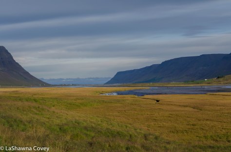
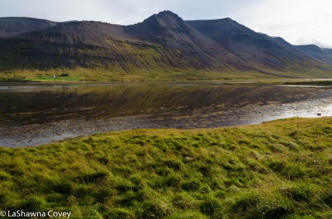
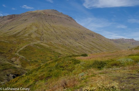
As I’ve written in many other blog posts, there is so much beautiful nature in Iceland. It’s like an embarrassment of riches if you love nature, and the sheer diversity packed on that small island, means you get major bang for your buck during a visit to Iceland.

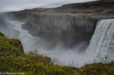
I’ve talked about other major waterfalls previously, such as Dynjandi and Dettifoss, but there are so, so many other waterfalls. Many of them are super famous for visitors in the first place, and many of them are easily accessible, just off a major road (so they are catnip for tour groups). Of course there are some other beautiful waterfalls I wanted to see, but either didn’t have the time to hike to them, or the type of car I needed to get to them. But there are enough diversity of waterfalls and ease of access, that you can satiate any thirst for waterfalls. I know I got my fill while I was there, and I can never visit too many waterfalls.

Iceland Waterfalls-2

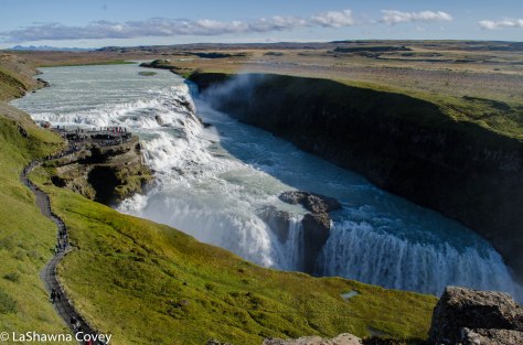
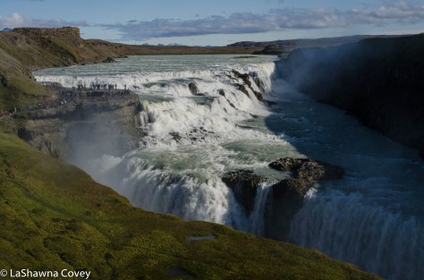
On our very first day in Iceland, literally just a few hours off an overnight flight to Iceland, we were standing at the edge of probably one of the most famous waterfalls in Iceland, which is Gulfoss. It’s not necessarily the best waterfall in Iceland (though I don’t know how you would determine which waterfall is “best”), and it’s not the biggest, but it is the most famous. Gulfoss is one stop on the super popular “Golden Circle” day tour of different sites around West Iceland (the other stops being Geysir, Pingvellir and usually a geothermal power plant). I daresay that the vast, vast majority of tourists to Iceland will see Gulfoss, either on an organized tour bus group or on an independent tour.

Most visitors probably don’t venture very far outside of the Reykjavik daytripper radius, so it is easy for tourists to take bus tours to see sites outside of Reykjavik, but not that far outside of Reykjavik. On my first trip to Iceland, I did the Golden Circle day trip, because it was just easier, and I hadn’t decided to rent a car to travel around Iceland at that point.

Iceland Waterfalls-5

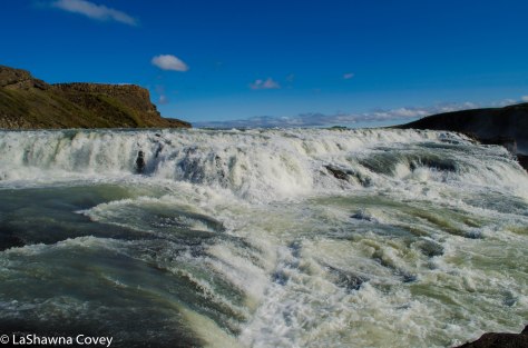
But planning this tour, I knew we would rent a car for a couple weeks, and would avoid Reykjavik altogether, simply to maximize time in the outer sites. But even though both my mother and I had been to Gulfoss, I wanted to see it again. Since both of our visits to Iceland were in the winter, we wanted to see the waterfall in warmer weather. A winter visit was really nice, because the surrounding area was covered in snow and ice, but the ice also meant that the trail to get closer to the waterfall was closed, but this time, we would be able to get up close and personal with the waterfall.

If you want to do your own self drive Golden Circle, it is super easy to do, since all the sites are located within a reasonable drive of each other, and all sites are well marked. That is one of the many nice things about driving in Iceland. Once you get outside of the Reykjavik metro area, there are usually only a few roads, and everything is well marked, so it is so easy to drive and not get lost.

Iceland Waterfalls-4

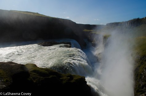
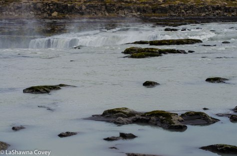
Since Gulfoss is super popular, you are guaranteed plenty of crowds when you visit (unless you visit really early or really late in the day). The waterfall is an odd and interesting setup, which only adds to the beauty of the site before you. You can view the waterfall from an overlook to get a wide expanse view of the falls and the canyon. The falls aren’t just one single falls, but rather multiple level falls. You can also hike down some stairs and a path down to stand right on the edge of some of the falls. The amount of water pouring through the canyon throws up a lot of mist that can obscure the canyon view, only to be exposed when the wind picks up.

Iceland Waterfalls-8

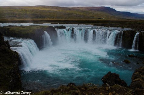
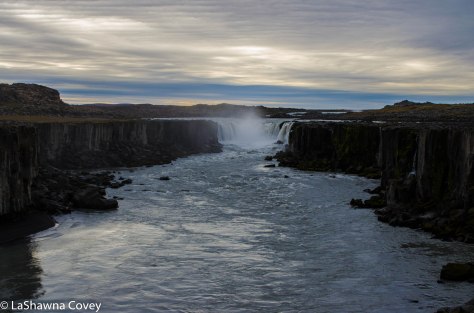
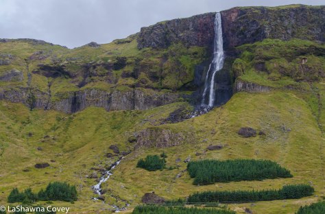
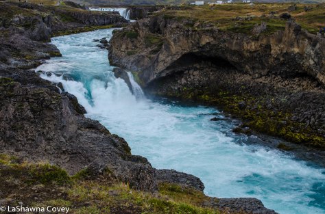
Another beautiful falls that is easily accessible is Godafoss, which is a nice, horseshoe-shaped falls that is located just off the Ring Road east of Akureyri on the way to Myvatn. This falls can be seen from the road, and there are two viewpoints on either side of the falls. Both sides provides a bit different view of the falls and the river, so it is worth it to stop at both viewpoints if you have the time. You can either drive the short distance between each waterfall side, or walk the easy path and bridge over the river.

Iceland Waterfalls-6

Both viewpoints require a tiny bit of scrambling over rocks, but it’s not that difficult if you are careful. Like all of the waterfalls in Iceland, there aren’t any guardrails. So it is incumbent upon visitors to be careful and not do stupid stuff that might result in them falling off high cliffs.

Iceland Waterfalls-7

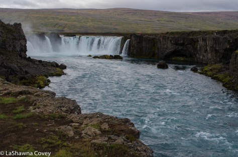
The view of Godafoss from up close and personal and from farther down the river are really nice, and provide many picture worthy settings. Godafoss is also worth your time. You are liable to see some tour buses at this site, but since you see far fewer tour buses outside of Reykjavik, it doesn’t overwhelm visitors trying to push their way through crowds for a good view.

Iceland Waterfalls-9

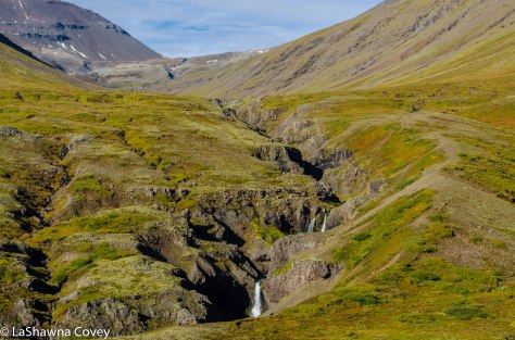
The next set of waterfalls I want to talk about don’t have any individual names (that I know of), but if you have time, they are absolutely worth your time. And I don’t think this site is really popular, so you have to know about it in advance (though it is known enough, that you won’t be on your own when you visit).

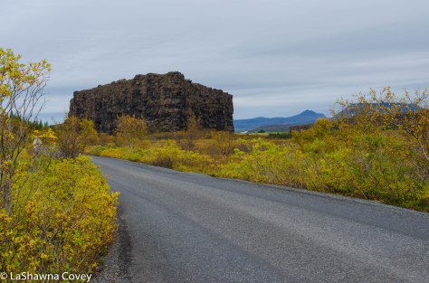
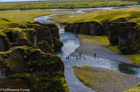
If you happen to be in South Iceland (and chances are, you will spend some time in South Iceland, either on your own or as a tour group), I would recommend making the time to visit Fjardargljufur, which is a picturesque, twisty, somewhat narrow canyon that houses some nice waterfalls.

Iceland Waterfalls-19

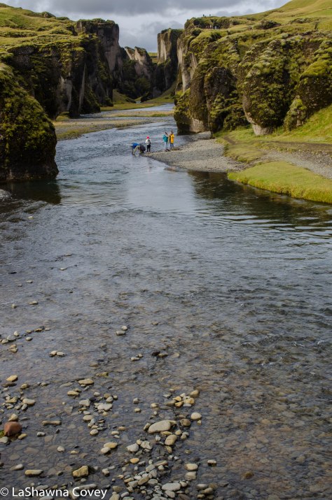
Reaching the car park for the canyon is rather easy. It is on Route 206, off the Ring Road, east of the town of Kirkjubaejarklaustur. Like all routes in Iceland, it is well marked  with a sign. The road to the car park is about 3.5 kilometers down a rutted, bumpy road. But by this point in our Iceland vacation, I was wearily used to bumpy gravel roads, so I just slowed down and knew I would get there.

IMG_1035

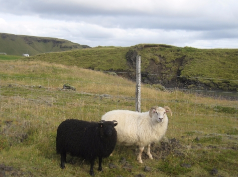
On the road, we finally got to see one of the things we had been hoping to see up close in Iceland, and that was a black sheep. Even though most of the sheep in Iceland are white, there are occasional sights of black sheep and mixed black and white sheep, but most of them were always off in the distance. The few times we had tried to approach a group with black sheep, they always ran away, because they seem so shy. But finally, we saw a white and black sheep just hanging out together just off by the side of the road. Here was our chance to photograph a black sheep. I was hoping to get a good photo, but by the time I got out of the car and got my camera out, they were running away like little sheep teases. However, my mother just had to roll down the car window and was able to snap a nice picture of the cute little sheep couple.

Iceland Waterfalls-15

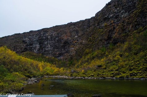
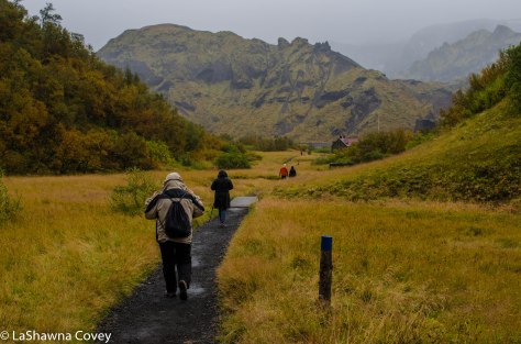
We knew we were at the car park, because we saw the long line of cars down the side of the road. Amazingly since this is not a hugely popular site, there is a nice bathroom right at the trailhead. The canyon is only about two kilometers out, the walk is very nice. The path is very well maintained, though there are some hills  since it follows the topography of the surrounding canyon.

Iceland Waterfalls-16

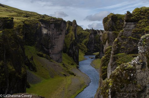
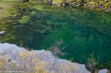
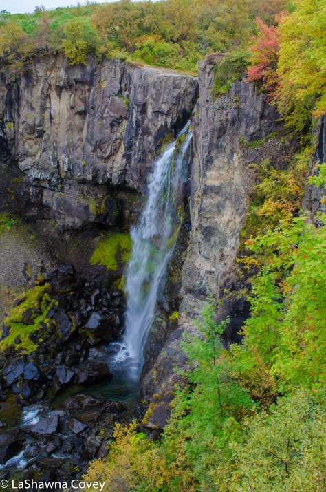
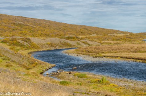
The trail is along the top of the canyon, and there are numerous viewpoints along the way that provide beautiful looks down into the canyon. The canyon walls were covered in moss, with a nice river flowing through it. My favorite views were the couple waterfalls, that were nice shapes and provided a different view of the canyon.

Iceland Waterfalls-17

Again, I highly recommend a stop at Fjardargljufur if you have the time. The walk is short and pretty easy, and a good excuse to get out of the car and stretch your legs. The canyon is a bit different than other places we visited in Iceland, and is almost like a glimpse into Middle Earth.

Iceland Waterfalls-18

The last two waterfalls I will mention are two rather popular waterfalls, and extremely accessible, as in they are both viewable from the Ring Road. And since both of these waterfalls are found  in Southwest Iceland, well within the Reykjavik tourist radius, you can count on seeing hordes of tour buses and rental cars. Which is fine. Just know before you go.

Iceland Waterfalls-10

Both of these waterfalls are a short drive between each other, so you can easily see them in one day. And to make it even nicer, both of these waterfalls look different and provide different views, so stopping at both waterfalls provides different viewing pleasures and don’t feel redundant.

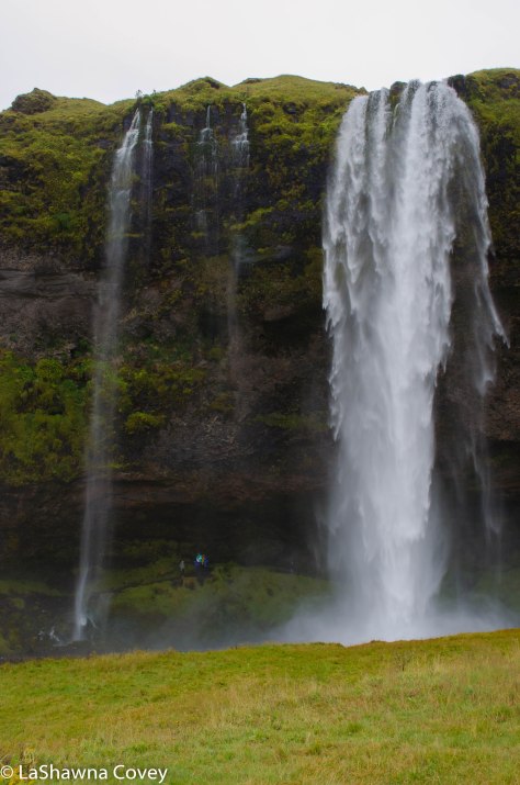
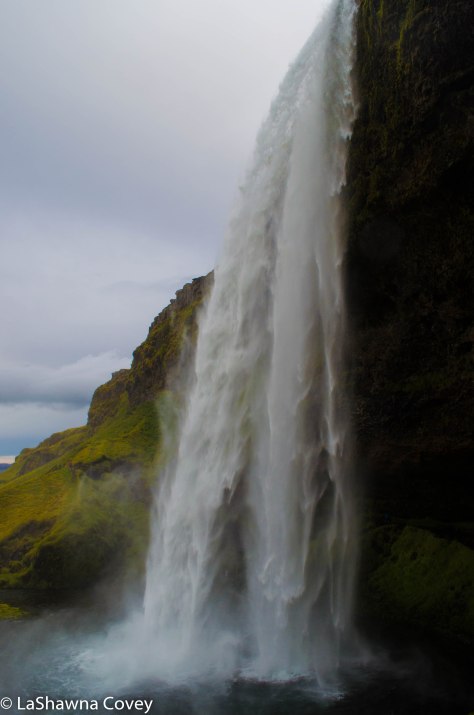
Seljalandsfoss is a long, thin waterfall located not far from Porsmork, so it is often a quick stop for Porsmork day tours. In fact, that is where we picked up our tour group, since we were coming from South Iceland. This waterfall must be popular enough to justify paid parking. It is only the second place I have seen paid parking (Skaftafell National Park being the other).

Iceland Waterfalls-12

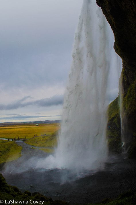
The view of the waterfall from a short distance is nice, but you also have the opportunity of walking around the waterfall and seeing the view from the back. Most people approach the back side of the waterfall from the right side, and from here, the waterfall mist will likely blow into your face if it is windy. Once you get behind the waterfall, the view of the falls is beautiful and the curtain of water adds the scenery. I made the mistake of following the path around the waterfall, instead of turning back from whence I came. The path from the right side is wet, but it is all rock. However, if you follow the trail behind the waterfall to emerge at the left side, you will find that the path is very muddy, slippery. I managed to scramble up the rocks, but I ended up with wet muddy boots and muddy clothes (thankfully you can wash yourself off in the river).

Iceland Waterfalls-11


The last waterfall, Skogafoss is just down the road from Seljalandsfoss. This waterfall is a different look, because it is a wider, more traditional looking waterfall. There is a big parking lot and an easy path to the bottom of the waterfall. You can walk right to the edge of the pool, though expect to be showered in waterfall spray. The day we visited the waterfall, the weather forecast was supposed to be a nice, sunny day (and it ended up being that way in the end), but for the brief time we were at the waterfall, the sky just opened up and dumped down on us.

Iceland Waterfalls-13

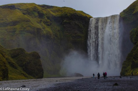
The nice thing about the rain is that it cleared out most of the tourists, including my mother who high tailed it back to the car. But since I was there and outfitted in a good rain jacket, I was determined to get some pictures from the top viewpoint. You can get a nice view of the top of the waterfall and the surrounding countryside by ascending the very steep set of staircases. Skogafoss is 62 meters tall, so it is not an insignificant distance, and you really feel it ascending to the top. The stairs are really nice and easy to ascend, but the sheer steepness required me to stop a few times and catch my breath.  But keep at it, and you will get to the top eventually.

Iceland Waterfalls-14

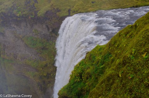
The view was good, even with the cloudy weather, since the rain had stopped by this point and the sky was brightening up. If you wanted, you could continue hiking from the top of Skogafoss to Porsmork, which is about a 23.5 kilometer trail. I elected not to do that, but the option is there if you so desire.

Like I said before, Iceland is an amazing wonderland of all sorts of nature, and if you love waterfalls in general, you will be in ecstasy while visiting this country. I wish I had been able to see a couple more waterfalls, but what I did was more than enough to keep me satisfied for a while.


Tramping through the Fall Foliage of Porsmork

Porsmork-10

When planning our second trip to Iceland, I had to balance doing the same things again, and doing completely new things. Outside of the Reykjavik daytripper radius, it was all new to my mother, so she was pretty much up for anything. I knew there were things that I had seen in the past, that she just had to see. Then there were things I wanted to do again, because this trip was during a different season. And there were things that were new to both of us. That was our day trip to Porsmork.

Porsmork-1

I was looking for new experiences, and during the course of researching this trip, I read about Porsmork and was intrigued. Porsmork is a nature reserve in southwestern Iceland that is filled with glaciers, rushing rivers, beautiful and colorful mountain views and verdant foliage.

Porsmork-2

What also intrigued me about Porsmork, is that even though it is not that far from the Ring Road in terms of geography, it is extremely hard to do an independent visit to Porsmork. Basically, unless you have a super high clearance vehicle AND good experience fording deep, rushing rivers, it is strongly advised that you go as part of a tour group.

Porsmork-3

So after some research, I selected a day trip to Porsmork with Extreme Iceland. They take these Super Jeeps that are capable of fording the rivers and take you out and about through Porsmork, stopping to look at glaciers and do some short local hikes. It seemed easy enough in terms of physical effort and a great way to see this part of Iceland I didn’t see my first trip.

Porsmork-4

Since we were coming from south Iceland to meet our tour, we elected the meetup at Seljalandsfoss, a beautiful waterfall that is close to the entrance of Porsmork. There is a paved road for a time after the waterfall, but soon enough, the road goes to gravel and starts to get much rougher. We trundled along at a nice clip, getting a good view of the nearby mountains and rivers, until we reached our first stop, which was a view of the small glacier of Myrdalsjokull.

Porsmork-5

This entire area around Porsmork was near ground zero for the massive eruption of Eyjafjallajokull in 2010, and the heat from the eruption abruptly melted a good chunk of the glaciers and formed these huge, rushing rivers.

Porsmork-6

It was around this time that the weather took a turn for the worse. It started out cloudy, and I was hoping that the predicted rain would hold off until the tour was over, but we were not that lucky. The weather wasn’t cold, but it was definitely wet, but in the beginning, the rain wasn’t too bad.

Porsmork-12

Due to the rising river levels because of the rain in recent days, we didn’t do one of the short hikes into Stakkholtsgja, which is a canyon that ends in a nice waterfall. The hike is through a canyon with a river flowing through it, and the river level was a bit too high to comfortably and safely hike to the waterfall.

Porsmork-13
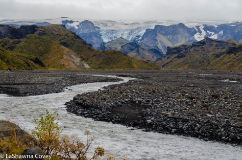
So instead, we drove out to Husadalur (Volcano Huts Porsmork), which is a terminus to the multi-day Laugavegurinn hike. It has a nice hut tucked into the forest, but is also near one of the many rivers in Porsmork and affords a beautiful view of the surrounding mountains.


Porsmork-8

The rain had lessened by this point, so we were able to do a short hike from the hut to a nice overlook of the valley. Even though we were in Iceland in mid September, the weather was cool enough that fall foliage had emerged in full. Having nothing to compare it to in Iceland, it certainly looked like south Iceland was near peak fall foliage. As a lover of fall foliage everywhere, it was great to see the colorful leaves as far as the eye could see in Porsmork.

Porsmork-11

Porsmork-14

By the time we got back to the van, the rain was coming down in earnest. We had a short lunch break at another hut of Basar. This hut was very nice, tucked in among the colorful trees and abutting steep mountains overlooking the site. I would have liked to enjoy it a bit more, but the rain was annoying enough that I wanted to get inside and stay dry.

Porsmork-17

Porsmork-16

After lunch, it was time to depart Porsmork, and this is when things got fun. The rain had been coming down for a while, and the river levels had risen even higher. This is when it is obvious why you need a super high clearance vehicle (though we saw one independent SUV make the the fordings, but we were all looking with baited breath to see if they would get stuck in the river and need to be rescued). I definitely would not want to visit Porsmork on my own, because even if I had a vehicle with high enough clearance, I have zero experience fording rivers, and there is an art to crossing these types of rivers safely.

Porsmork-9

Even though we didn’t get to see everything due to the rain, it was still a very pleasurable day trip. We got to see a part of Iceland that is not easily accessible, and just enjoy the isolated beautiful nature. If you have the time and money (the tour is not cheap, since it costs rougly $230-$250 per person, depending on where the tour picks you up), I definitely recommend a jaunt out to Porsmork.

Porsmork-15


Enjoying the Waterfalls and Glaciers of Skaftafell National Park

Skaftafell National Park-4

As I’ve talked about in previous blog posts, South Iceland is just filled with beautiful nature of an incredibly diverse sort. It is quite amazing that for an area that really isn’t that big, you can find nearly so many different ecosystems .

On one of many days in South Iceland, I budgeted a full day for Skaftafell National Park, though I didn’t think we would need the entire day. Skaftafell National Park is the southern part of the larger Vatnajokull National Park.

The park itself is rather big, but for most day trippers, the bulk of the sites are within a couple miles walk of the visitor’s center. The two biggest attractions for visitors are Svartifoss and Skaftafellsjokull. Both of them are reached by well-maintained trails with under an hour of walking, but there are also more longer, more difficult trails for those who want to venture deeper into the park.

Skaftafell National Park-11

I knew Skaftafell National Park is a very popular destination, with some estimates of 500,000 visitors per year, making it one of the top attractions in the country. So even though we were visiting during the shoulder season, and not high tourist season, I wanted to get to the park early so we could beat a large part of the crowds.

Skaftafell National Park-6

Skaftafell National Park is easily reached off Ring Road 1, with a well marked sign. Like all of the other national parks and attractions in Iceland, admission to the park is free. That is one of the very nice things about visiting Iceland. I am so used to America charging admission to a good number of their parks and other beautiful nature sights. However, there is one thing about Skaftafell that is uncommon in the rest of the country: they charge for parking. I only encountered this in two different sights in Iceland: Skaftafell National Park and Selijalandsfoss. Having gotten so used to everything being free, this took me aback a bit. But the parking charge is about six dollars for 24 hours. And considering how this park is probably feeling the weight of the tourist crush, I can’t say I blame them for charging for parking.

Skaftafell National Park-2

Since we got there early, the parking lot wasn’t too full, and there weren’t that many tour buses. After a brief overview of our two planned trails at the visitor center map, we set off to see Svartifoss first. I knew that was the MOST popular sight, so I wanted to see it before the crowds set off. Shortly after we set off on our 1.8 kilometer hike to the waterfall, I realized we had been had by my guide book. My guide book had designated the trail as “easy”, so I figured the trail would be mostly flat and well maintained. Well…I got half of that right. The trail is very well maintained, with most of it cement, and the a good chunk of any uneven ground is covered in plastic coverings. But flat? That’s a laugh. The trail is nearly all uphill for the route to the waterfall. And when I mean uphill, I’m not talking a gentle incline, but rather steep in more than one part. It was quite the puffer at times, and I took advantage of the some of viewpoints of other waterfalls, or viewpoints of the surrounding countryside, to catch my breath.

Skaftafell National Park-1

Eventually, we saw a nice waterfall off in the distance, and wondered if that was Svartifoss. Even though it had basalt columns like was described in my guide book, I dismissed it initially, because the waterfall looked too small to be a large tourist attraction. But once we got closer to the waterfall, I could see that yes, in fact it was Svartifoss, but thankfully it looked more majestic up close. You can view the waterfall from a bit of a distance at the bridge that crosses the river, or you can take a short trail to the base of the waterfall for a very nice view.

Skaftafell National Park-3

The waterfall looks really nice up close and personal, and the basalt columns are interesting to look at, with the combination of basalt vertical columns and hexagons, formed by differing sorts of volcanic activity.

Skaftafell National Park-5

After admiring the waterfall for a bit, we continued on up the trail out of the valley. You can turn back and take the trail down the way you came up, though it really isn’t encouraged. Due to the large volume of tourists, the park requests you take another trail back, so as to control the flow of people traffic. The trail back was nice. It wasn’t anything overwhelmingly beautiful, but it provided some nice views of the surrounding countryside. We could also see the hordes of tourists making their way up the hill to visit the falls and we were glad to miss the tourist crush. Even more so, when we got back to the visitor center and saw the lines of buses parked in the lot.

Skaftafell National Park-8

For our next hike, we walked out to Skaftafellsjokull, which is a glacier within the bounds of the national park. My guide book promised an easy 1.8 kilometer walk to the glacier, and this time, they were right on the money. The trail is flat and you can see the glacier off in the distance when you start, growing bigger as you approach it.

Skaftafell National Park-9

This glacier is like a junior version of Fjallsarlon. The glacier is not that big, and like he rest of Iceland’s glaciers, it is retreating, and leaving behind a growing glacier lagoon in its wake. Due to the deep looking, fast moving glacier river that comes from the glacier, you can’t just walk up to the glacier, but rather view it from a short distance. It’s not the most impressive glacier in South Iceland, but it is still nice to stop and marvel at the sheer accessibility of Iceland’s glaciers, a fact that is liable to change in the coming years through glacier retreat due to climate change.

Skaftafell National Park-10

Even though I had budgeted the entire day for Skaftafell, it took really only about a half a day. So we headed back to the hotel to relax in our nice, warm hotel room and plan for further adventures. Skaftafell is super easy to reach in South Iceland. Just know that is a popular tourist attraction, so plan accordingly.

Enjoying the Icy Beauty of South Iceland’s Glaciers

South Iceland glaciers-4

One of the many pleasures in visiting Iceland, is that you can experience a number of different ecosystems and micro climates, all within a relatively short distance. I mean, you can visit temperate forests, a variety of beaches in multiple colors, geothermal sites of lava fields and steam pits, and glaciers. I have been to a wide variety of countries, and none of the countries I have visited have so many glaciers so accessible to the average person.

South Iceland glaciers-1

There are a variety of glaciers in different parts of the country, but the most accessible ones are the multiple ones in South Iceland. In this part of the country, you can easily see the glaciers spilling out from the mountains as you drive down Ring Road 1. And most of these glaciers are easily visited with only a short walk from a parking lot. It’s an awe inspiring glimpse into nature, one that is becoming more and more threatened over the years as the glaciers recede.

South Iceland glaciers-2

Probably the most popular glacier site to visit (and probably also the most beautiful) is Jokulsarlon, which is a glacier lagoon just off Ring Road 1, in the southeast part of Iceland. This is the largest glacier lagoon in Iceland, and it is getting bigger all the time, as the glacier recedes, creates more icebergs  and a bigger lagoon.

South Iceland glaciers-3

This is a site that is literally impossible to miss as you drive down the road, either from the lagoon itself, or the hordes of tourists in the parking lot. We approached Jokulsarlon coming from the east, because this was our second to last stop on our very long day of driving from north Iceland. We got there late afternoon, so there weren’t as many tourists, but it still was a bit of a shock to the system to see so many tourists after days of only small groups in the west and north.

South Iceland glaciers-5

You have some options when visiting Jokulsarlon when it comes to activities. There is no admission fee to the site itself (a common occurrence for the nature sites in Iceland), so you can just walk up and down the shores of the lagoon, taking in all the different angles to enjoy the different icebergs. You can walk all the way out to the beach where the icebergs eventually float into the sea after bobbing around the lagoon for a few years. It is also possible to take a boat ride in the lagoon (for a fee of course), which will get you more up and close and personal with some of the icebergs. I took a boat ride on my first trip to Jokulsarlon, but we elected not to this time.

South Iceland glaciers-8

The lagoon itself is quite large, with most of the iceberg chunks clustered in an area together, and you can see the parent glacier off in the distance. This lagoon is accessible year round, though as you can imagine, the views are a bit different in the winter when it is colder. This is one of those sites where you see it literally when you get out of the car. There is a small hill where you can get a good vantage of the overall lagoon, but this is one of the easier beautiful nature sites to visit. You could spend a lot of time just taking in all the different glaciers and imagining what the different shapes represent. My favorite icebergs were the blue ones, just because it really added a lot of icy winter beauty to the scene.

South Iceland glaciers-11

Our last stop for the day was just down the road at the other glacier lagoon of Fjallsarlon. This glacier lagoon is sort of the junior version of Jokulsarlon, because it is much smaller. The lagoon itself isn’t as big, nor are there are many icebergs as Jokulsarlon. However, you are much closer to the parent glacier. It isn’t a small thing off in the distance, but rather right in front of you. This glacier is easily viewed from the road at quite a distance, and it wasn’t until we got closer, we realized this was actually our destination of Fjarllsarlon.

South Iceland glaciers-9

Unlike Jokulsarlon, you will have to walk a little bit from the parking lot, but it’s only several hundred meters of a gravel path, and then you find yourself standing on the shores of the lagoon, looking up into the glacier. It is also possible to walk between the two glaciers on a path several kilometers, but since it was late in the day, I wasn’t exactly feeling it. I wanted to get to our hotel and relax.

South Iceland glaciers-10South Iceland glaciers-7

The next day, we visited a couple of sites, such as Skaftafell National Park (covered in an upcoming blog post), where we hiked out to the resident glacier. But on our way back, we stopped at another glacier, called Svinafellsjokull. This is another glacier that is easily accessible to the public, though instead of being just off the road, the parking lot is down a very rutted gravel road. I had visited the glacier on my first trip, but for whatever reason, I either thought I couldn’t drive down to the parking lot, or wouldn’t be able to get my car, because I ended up walking the 2 kilometers each way to the glacier. This time I didn’t make the same mistake.

South Iceland glaciers-13

The trail to the glacier viewing site is a short hike from the parking lot, and the view soon opens up to see the glacier itself and its own lagoon. Even though it has only been six years since my first trip to Iceland, I could see where the glacier has receded and opened up the lagoon even more.

South Iceland glaciers-12

Once you get to the best viewing site, it is possible to scramble over the rocks a bit more to scramble up the canyon, though I don’t think you will necessarily get a better view farther up. On many of the glaciers in Iceland, it is possible to visit and hike on the glaciers as part of a guided tour. There are numerous warning signs around many of the glaciers cautioning people from attempting to walk on the glaciers themselves, because there are all sorts of hazards and dangers that can hurt or kill you if you don’t know what you are doing.

South Iceland glaciers-14
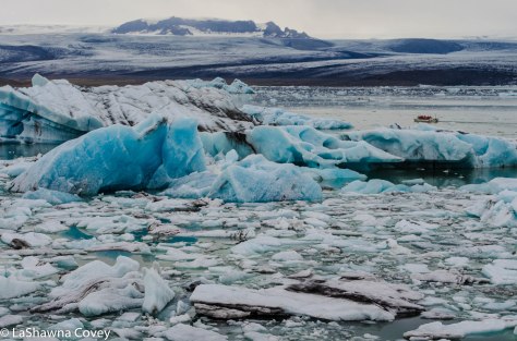
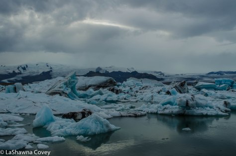
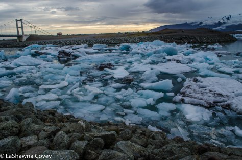
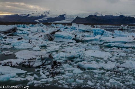
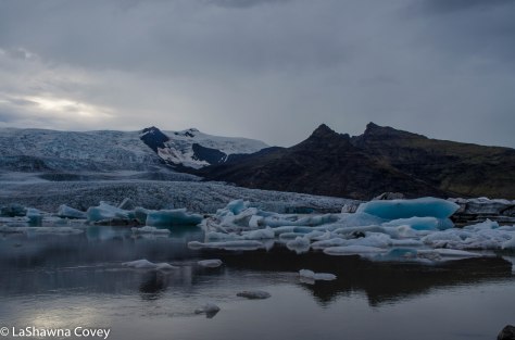
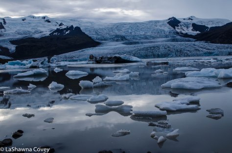
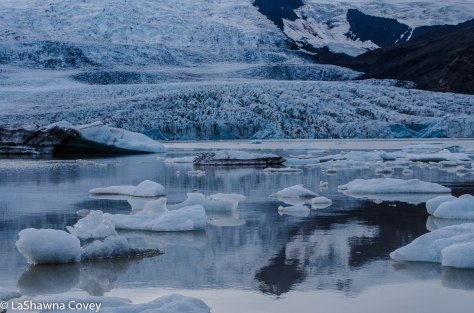
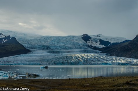
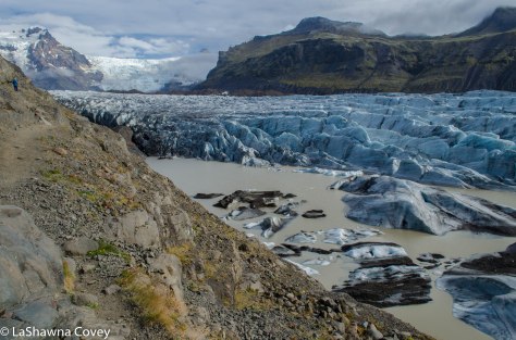
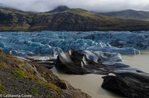
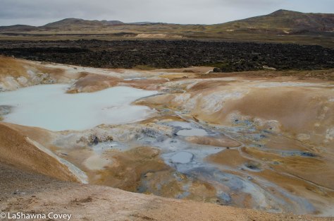
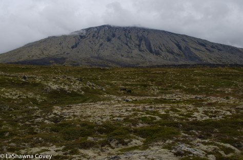
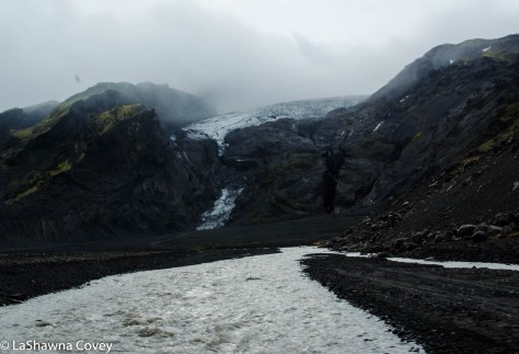
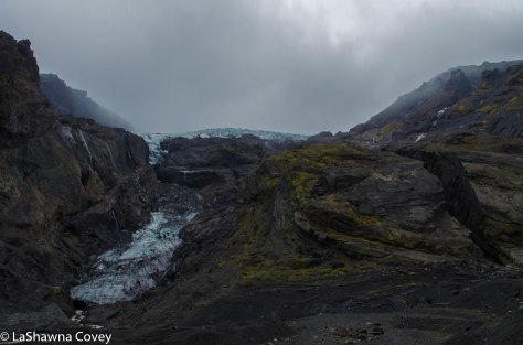
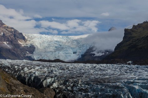
It is remarkable that in so many other parts of the world, glaciers are considered these exotic things, farflung from civilizations and hard to access, but in Iceland, they are literally just down the road and easily accessible for all to see.South Iceland glaciers-15


East and South Iceland Beautiful Nature Pleasures

South Iceland beautiful nature-13

After spending more than a week enjoying a lot of the pleasures of Western and Northern Iceland, it was finally time to make our way down to the final leg of our trip, which was in South Iceland. That meant one very LONG day of driving, because we were starting our day in Myvatn and finishing it up at our hotel in the central part of South Iceland.

South Iceland beautiful nature-1South Iceland beautiful nature-4

This was our longest stretch of driving in a day, not necessarily in number of hours on the road, but rather the number of kilometers driven. We logged over 400 kilometers in our car, but thankfully 99% of the drive was on fully paved roads. Driving this long leg is not the most ideal, but I considered it rather necessary. Sure there are plenty of things to see and do among the fjords in Eastern Iceland, but we just didn’t have time to fit those things in along with everything else we wanted to see in two weeks. Hence, the very long day of driving to set us up for the final days of our trip.

South Iceland beautiful nature-5South Iceland beautiful nature-3

This is not the first time I made this drive, since I did the same amount of driving on my first trip to Iceland. That one was during the winter, and I ran into the same issues you can expect when driving on ice and snow. For reasons, I can’t quite figure out, once you get to the town of Egilsstadir, the main road splits. Sure that is understandable, because one takes you almost directly east to the coast, and the other one splits down and goes further south. What is odd is that only one of those roads is fully paved, and it’s not the one you think. No, it’s not the Ring Road 1, which is Iceland’s main highway that circumvents the island, but rather Routes 92 and 96. Sure, Ring Road 1 does continue south, but a good chunk of this portion of the road isn’t fully paved and it’s not even easily accessible during winter months if there is snow and ice on the road.

South Iceland beautiful nature-7

I learned this point the hard way on my first trip. I tried to take a “shortcut” that would have cut my driving time significantly, but it was so laden with ice, that I had to turn around on a narrow road. I kept envisioning that I was going to slide off the road into the ditch and be stuck there for a very long time before help comes along (I had encountered that situation earlier on my trip in another part of Iceland), but thankfully I had made it back to the paved road.

South Iceland beautiful nature-6South Iceland beautiful nature-2

Even though the weather was clear on our second visit, I was completely over driving on gravel road and would rather take a little bit extra time to drive on paved roads. The drive east from Egilsstadir to the coast, is one of the most beautiful stretches of road I drove in Iceland. The road wound around the hills as we descended from the heights of northern Iceland to near sea level of eastern Iceland. The hills rose steeply around us, and we passed numerous beautiful waterfalls, easily viewed from the road. We stopped when we could, but I wish this road had more pullouts to stop to gawk and take photos.

South Iceland beautiful nature-9South Iceland beautiful nature-10

Once we hit eastern Iceland, the road followed the geography of the fjords, so we didn’t have too much to do, but just enjoy the scenery around us, and make occasional stops, such as an outdoor art exhibit of numerous stone sculptures in the shape of eggs of Iceland native birds. This exhibit is called Eggin i Gledivik, and makes for a short diversion. It’s a pretty exhibit in a pretty area, and is a good chance to stretch your legs from the long bouts of driving (at least it was for us).

South Iceland beautiful nature-8

There is so much to see and do in South Iceland, that you will need at least a few days if you want to see most of it at a leisurely pace. It is also here when you know you have linked back up with the Iceland tourist blob. Sure there are tourists in other parts of Iceland, but the vast majority of tourists don’t venture too far outside of the Reykjavik tourist radius. That radius does extend as far south and east as Jokulsarlon (a site I’ll cover in my next blog post), and the closer you get to Reykjavik, the more tour busses and more crowds you will see. The difference is stark and very noticeable. While beautiful, this is not part of Iceland you go if you want to enjoy splendid isolation (that’s what the Westfjords are for).

South Iceland beautiful nature-12
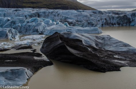
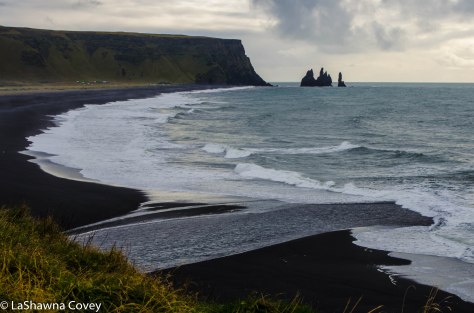
The farthest south you will see most daytrippers from Reykjavik is the town of Vik, which is on the western side of south Iceland. Among the numerous natural pleasures in the area or within short driving distance (which I will cover in future blog posts), one of the nicest (and therefore most popular) are the sites of Dyrholaey and Reynisfjara. They are two distinct areas, but you can see one from the other. South Iceland beautiful nature-16
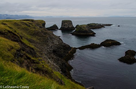
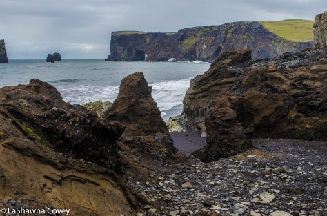
The first place we stopped was Dyrholaey, which is a beautiful rock formation, sea arch, and black sand beach. During nesting season, it is also home to a variety of birds (we visited out of bird nesting season). One of the viewpoints at Dyrholaey overlooks the western side of Reynisfjara black sand beach. From this viewpoint, you can see the sea stacks of Reynisdrangur. However, what captured my eye was the freshwater river that originated somewhere farther inland, most likely from one of the many, many glaciers in the area that flowed into the sea. I wanted to get close to it and see it for myself, but there is no easy way to walk down to the beach from the viewpoint. South Iceland beautiful nature-15At another vantage point, you can also see the sea arch off in the distance and a beautiful black sand beach down below. I remember this beach from my winter trip, because at the time I visited, it was covered in pure, virgin snow (except for a step of footprints), and I was entranced with the contrast between the pure white of the snow and the pure black of the sand. This time however, we weren’t supposed to go down to the beach, because it was closed.South Iceland beautiful nature-14After that, we drove a short ways down the road to Reynisfjara. While Dyrholaey is popular with tourists, Reynisfjara is another thing altogether. Hordes of tourist buses regularly show up and discharge their passengers for a short walk around the beach with a chance to look at a basalt sea cave, and a closer look at the sea stacks.South Iceland beautiful nature-18
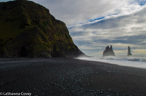
It is a very beautiful site, but as you see from the warning signs before you walk onto the beach, and what is apparent from just observing the beach for a few minutes, it can also be a very dangerous beach. This beach is notorious for sneaker waves, which are very powerful waves that can easily knock someone down or pull them out to sea. The occasional tourist death happens at this beach when people don’t respect the power of the ocean. The ocean is not placid at this beach, but rather filled with reasonably large, powerful swells, along with some powerful ocean currents. South Iceland beautiful nature-19This beach is also a good reminder that while Iceland has many, many beautiful beaches, this country is not what you would consider a “beach destination.” I mean beach destination in the sense that you would want to hang out on the beach all day and frolic in the water, even on beaches where the sea doesn’t rage as much. The ocean is simply too cold to swim or play in at all, even in the summertime (it doesn’t get that hot in Iceland in the summer). So beaches here are great to visit and enjoy the seascapes and beautiful nature, but not to play in the water. South Iceland beautiful nature-17
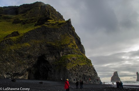
From the entrance point to Reynisfjara from the parking lot, we could see the cliffs of Dyrholaey off in the distance, and it didn’t look TOO far away (though it proved to be around a couple miles). So we just started ambling down the beach, first to get away from the hordes of tourists mucking up the background of our photos, and then later just to see how far we could get. I was hoping to get close to the glacier river I saw at the Dyrholaey viewpoint, and eventually we found ourselves at the banks of that river. After taking in the view, we turned around and made our long way back to the parking lot. South Iceland beautiful nature-21South Iceland beautiful nature-22There are so many beautiful things to see and do in South Iceland, that I can’t do it proper justice in one blog post, but I have a few others coming up that highlight all there is to see and do in the area. Even though you do see daytrippers coming down on a tourist bus, that way is simply too superficial to really see everything. I would highly recommend you rent a car and see this area at your own pace. Just know that you will be one of many, many tourists taking it all in. South Iceland beautiful nature-20


Waterfalls and Other Natural Wonders in Jokulsargljufur National Park

Vatnajokull National Park-9

Staying around the Myvatn area not only has its own local pleasures (detailed in my previous two geothermal posts), but it also serves as a great base for seeing sights further afield. One of the ones I most anticipated visiting was Vatnajokull National Park. The park itself is rather large, and the result of merging two previously separated parks- Jokulsargljufur and Skaftafell National Parks. Jokulsargljufur is in the north east of the Myvatn area, and Skfaftafell is in the south, both accessed by different parts of Ring Road 1.

The highlight of Jokulsargljufur, and one of the highlights to any Iceland trip (especially if you are a waterfall aficionado like me), is Dettifoss. While Dettifoss is not the tallest waterfall in Iceland (that would be Glymur, which is located off the head of Hvalfjordur in the west, north of Reykjavik), it is considered to be the most powerful in terms of water volume. It has been featured in numerous movies, and I just really wanted to see it. I had hoped to see it on my first trip to Iceland, but the snow reared its ugly head again. Sure, the main road to Dettifoss is paved, but it is 24km from the Ring Road to the parking lot, and that is a lot of road to plow in the winter, with fewer visitors to justify it. Though again, that was in 2011, and with the increasing number of winter tourism, hopefully the government is keeping the roads to the more popular attractions plowed.

Vatnajokull National Park-1

My mother and I got started early on our day trip to Jokulsargljufur for a couple reasons. First, we wanted to beat the crowds to Dettifoss and see the waterfall without a lot of people around. Second, Dettifoss was not our only stop in the park. There is lots more to see and do in the area, and I wanted to drive up the park road to the northern edge around Asbyrgi in the north and do a lot of short, but scenic walks along the way.

Like I said, Dettifoss is easily reached from Ring Road 1, and it is about a 20 minute drive east of Myvatn. There are actually two roads you can access the falls, one on the west side of the falls and one on the east side of the falls. The western access point is the more popular site and is called Route 862. This route is paved all the way to the Dettifoss parking lot. I’ll talk about the eastern access in a bit, because that is a story in and of itself.

Vatnajokull National Park-2

We did get there early, and there were only a handful of cars already there, which gave us great relief. Based on the sheer size of the parking lot, along with the numerous tour bus parking spots, it is obvious how popular it is. I can only imagine the hordes of crowds in the tourist peak summer.

From the parking lot, it is about an 800 meter walk to the falls viewing site, but you can see the spray rising in the distance. The walk to the falls is easy and flat and well marked. We went straight to the falls first to get our first view of Dettifoss and it did not disappoint. The western side has more dedicated viewing platforms, but it also has more fencing to protect visitors. Even so, you are still pretty close to the falls. The sheer volume of water spilling over the falls is astounding to behold, and the sound is thunderous. We could just stand there and take it all in. The water is a milky white, because it is being fed by a glacier upstream.

Vatnajokull National Park-3

Dettifoss may be the biggest and most famous waterfall in Jokulsargljufur, but there are others. One of them is called Selfoss, and is located about 1 kilometer north of Dettifoss. Again, the path is well marked, flat and easy to follow. After we had our fill of Dettifoss, we headed out to that falls. Selfoss is a much smaller, though still pretty, horseshoe shaped falls. Unlike Dettifoss, the best view of the falls (at least on the western side) is from a distance a few hundred meters away. Even though you can get close to the falls  near the head, just the configuration of the land and the large width of the pool feeding the falls prevents any better view of the falls close in.

Vatnajokull National Park-6

Vatnajokull National Park-7

By the time we got back to our car, the tourists were starting to come more en mass, so we smirked at how we beat most of the crowds. Our intention was to continue driving north on Route 862, with our next planned stop around Vesturdalur, which is a nice camp site halfway through the park that was supposed to have some beautiful rock formations. However, that was not to be. Most of Route 862 north of Dettifoss to Asbyrgi is gravel, but the government is making steady progress paving the whole way. So much progress, that they were paving the road at the time of our visit, and had blocked it off to the rest of traffic. So we were forced to turn around.

At that point, it became a debate about how best to see the rest of the park. My first instinct was to drive ALL the way around to the north, but that would have taken at least an hour (probably more), even though the roads itself would be paved. OR we could take the alternate route to Asbyrgi, which is the eastern route called Route 864. I had been hesitant to take it, because our guide book emphasized how rocky and rutted the gravel road was. But considering it said the same thing about the roads in the Westfjords and I felt it overstated the road conditions, we figured we would at least see how bad the road was, because using the eastern route could save on a lot of useless time driving.

Vatnajokull National Park-4

So even though I had not intended to use the eastern route, now I found myself navigating the road. However, I figured there was an upside to taking the eastern route, and that was visiting the eastern side of Dettifoss. More on that in a bit, because we first had to get there, and at some point in the 24 kilometer drive to the Dettifoss parking lot, I almost gave up and turned around. While I have not driven every road in Iceland, I can say with confidence that Route 864 from the Ring Road north to the eastern Dettifoss parking lot, is the worst road I drove in Iceland. I could barely get above 10 kph, because the ruts and potholes were so frequent. Now granted, this would not be a problem for all vehicles. We got passed by numerous larger, SUVs who barrelled by us with their bigger tires, 4WD, and higher clearance, while we putted along in our tiny, low clearance car that shook with every rut and pothole we encountered. So as tempted as I was to just chuck it all in at certain points, I kept going. Part of it was out of sheer stubbornness, since we had started this adventure. Part of it was now out of a desire to see the eastern side of Dettifoss and Asybyrgi. And part of it was because I did not want to drive back on that road if I didn’t have to.

We both breathed a sigh of relief when we finally arrived at the parking lot. By this point, it was midday, so the parking lot was full of cars, but not near as many cars as on the western side. Since Route 864 is so bad, it discourages many tourists, and honestly, it is for the better.

Vatnajokull National Park-5

The path from the parking lot to Dettifoss is about the same distance as on the western side, but it is mainly downhill (so it will be uphill on the return to your car). The path is not as well maintained, and when you get closer to the falls, it is basically just walking over large rocks. The views from the eastern side are different, and provide a more expansive view of the surrounding canyon.

But the BEST part of visiting the eastern side of Dettifoss, the main reason I would recommend it if you have the time and patience to drive the horrible road, and the main reason why I think the government allows the road to stay horrible, is because you can literally stand on the edge of the waterfall. I mean, there is NOTHING between you and the falls. No fence, nothing. You could easily just stick your hand in the water and feel its power. Of course, you could also do something reckless and stupid that could ensure you fall to your death, but I would like to think anyone who would drive to the eastern side of the falls, has enough common sense and protective instincts to respect Dettifoss and not do anything stupid.

Vatnajokull National Park-10

The view is so amazing, just because you are so close to the falls and can REALLY feel its thundering power, that I didn’t want to leave. But leave we must, so after getting back to our car, we had a decision to make. Do we take the devil we know- the potholed road from hell back to the Ring Road- or the devil we didn’t- the rest of Route 864 north. We decided we would at least try  the road north, figuring we could turn around at any point if it became too hellish.

Vatnajokull National Park-11

And wouldn’t you know it, but the road north of Dettifoss is MUCH better . I mean, light years better. Sure there are still some potholes, but overall, it is better maintained and graded. We could even pick up some speed as we headed north. There is no access to Vesturdalur from the eastern side, but there are other views to be had.

Vatnajokull National Park-8

We saw our third waterfall of the day called Hafragilsfoss. It is located a short ways downstream from Dettifoss, and can actually be reached by a trail from the Dettifoss parking lot. But if you don’t want to walk to it, there is a marked car park that overlooks the falls. You aren’t particularly close to the falls from the car park viewpoint, but it is a very pretty, expansive view of the falls and the canyon.

Vatnajokull National Park-12

After Hafragilsfoss, we pretty much sped up Route 864 until we hit the main road of Route 85. Even though driving up the eastern road to Dettifoss took a lot out of me mentally (yeah, I know), we still wanted to see Asbyrgi.

Vatnajokull National Park-13Vatnajokull National Park-14

Asbyrgi is the northern edge of Jokulsargljufur, and it is an enclosed canyon that is filled to the brim with verdant foliage. You can easily drive in the canyon on a paved road from the visitor’s center. We took the road all the way to the end (only 3.5 kilometers) to the car park. From the car park, there are a variety of short hikes. We elected to take the trail to Botnstjorn, which ends at a scenic duck pond at the head of the Asbyrgi canyon.

Vatnajokull National Park-16Vatnajokull National Park-17Vatnajokull National Park-15

It was nice to see that a lot of foliage was turning colors for fall, and the whole surroundings were just peaceful. At this point, we had our fill of the canyon for the day and headed back to the main road, with only a short stop to photograph Eyjan, which is this odd and large rock outcropping in the middle of the canyon.

Vatnajokull National Park-19

I highly recommend a full day trip to Jokulsargljufur. Sure you could just see Dettifoss (from the western side) and be done with it, but there are plenty more natural treasures within the park. There are many short walks, none of which are exceptionally difficult, though this park also plays host to a beautiful two day walk all the way up the canyon from Dettifoss to Asbyrgi. But even a car trip is worth it. Hopefully Route 862 will be completely paved soon enough, though even the gravel road is probably fairly well graded. But you shouldn’t regret taking the time to see as much of the park as you can.

Vatnajokull National Park-18

Geothermal Pleasures in Myvatn- Part 2

Myvatn geothermal-17

After spending a couple hours tramping through the lava fields of Leirhnjukur, we made our way to Hverir, which is literally just down the road from Krafla. It’s pretty hard to miss from the  Ring Road, as you can see the steam rising from the mud pits (and it’s very well marked with a sign and a full parking lot).

Myvatn geothermal-24

Myvatn geothermal-19

Hverir is a beautiful, otherworldly  landscape of steam vents, bubbling mud pots and colorful mineral deposits. Hverir definitely reminds me of some of the wild, colorful areas in Rotorua, New Zealand. Like so many other natural attractions in Iceland, it is easy and free to visit. Sure, there are warning signs to avoid certain places, and the more dangerous areas are roped off, so you don’t accidentally wander into a boiling mud pit, and fall through the thin crust of the earth. But in general, it is up to every visitor to exercise caution and behave responsibly.

Myvatn geothermal-21

Myvatn geothermal-20

The easiest way to see Hverir comprehensively is to just circumvent the area. There are a couple of vents with hot steam pouring out of it, and there are a lot of mud pits. Sure the mud looks like a nice pleasant mud bath, but it is important to remember that the mud is actually boiling.

Myvatn geothermal-18Myvatn geothermal-25

From Hverir, if you are so inclined, you can walk up the Namafjall ridge. The trail is clearly visible. If we hadn’t just gotten in our daily fitness goal of steps, I might have been tempted, but I begged off since there was still plenty of activity planned.

Myvatn geothermal-23

Visiting Hverir usually takes about 30 minutes (assuming you don’t hike up Namafjall) for a nice, leisurely visit.

Myvatn geothermal-16

Myvatn geothermal-22

Our first night in Myvatn ended with a beautiful sunset. These were probably the most beautiful sunsets we experienced while in Iceland. There were very few clouds in the sky, and what clouds there were, just added to the colorful drama as the sun set behind the lake and produced amazingly reflections.

Myvatn geothermal-28Myvatn geothermal-29

While we had other activities in the Myvatn area our second day, we came back shortly before sunset and figured this was a perfect opportunity to visit Hverfell. It is a large crater that sort of overlooks the villages around Myvatn (though it is somewhat easy to miss if you don’t know what you are looking for initially, since it sort of blends in with the surrounding mountains.

Myvatn geothermal-31

We had some time to kill before visiting the Myvatn Nature Baths and it was just down the road. For a nature attraction that is so close to the road (and presumably a large tourist draw), it was surprising just how rutted the road was. But I drove slowly and we eventually made it to the parking lot at the base of the crater.

Myvatn geothermal-27

From the road, you can see the path that ascends from the parking lot to the top of the crater (and circumvents the crater), and we read that the path was only 600 meters, which sounds pretty short. And yeah, the path is short, BUT, you will feel nearly every step up the path. It is a very steep path of somewhat loose gravel. I was huffing and puffing and took plenty of breaks, but we got up to the top.

Myvatn geothermal-32

From the top of the crater, we had a very nice view of Myvatn and the surrounding area that was warmly lit by the setting sun. If you have the time and the energy, you can walk around the entire lip of the crater, which is about 3.2 kilometers. By this point, I didn’t have the energy and contented myself with enjoying the view of inside the crater and the landscape.

Myvatn geothermal-35Myvatn geothermal-34

After a long day of walking, relaxing in the warm, steamy pools of the Myvatn Nature Baths were just the perfect end to a great day. The Myvatn Nature Baths are North Iceland’s answer to Reykjavik’s Blue Lagoon, but it is a bit different experience. It is a smaller facility, owing to the fact that most of Iceland’s tourists seem to stay in and around the Reykjavik area, and far fewer venture afield. There are a couple of large, hot geothermal pools that overlook the lake.

Myvatn geothermal-33

We figured we would stay until sunset and then go back to our hostel and fall fast asleep. However, thankfully we were dawdling a bit, and we got a small glimpse of the Northern Lights, which was surprising for a couple reasons. First off, it was only 2100 in the evening, and the conventional wisdom was that Northern Lights don’t make their appearance until after midnight. And secondly, the night was pretty clouded up, and fairly clear nights are needed to see the Lights. However, the bright, green auroras we did see were even visible through the clouds. We didn’t even notice them at first, but we knew something was up when we heard the cheers of joy from the other persons in the baths. The display didn’t last for long, but we did get to see just teasing hints of what was probably visible under the clouds. If only the night had been clearer, because it would have been an amazing experience to watch the Northern Lights dance across the sky while we stayed nice and warm in the outdoor geothermal baths.

Myvatn geothermal-30

This was my second trip to Myvatn, and it was a very enjoyable experience. Most of the geothermal sites are easily accessible in the winter (though again, some of the roads may not be plowed if it snows), so Myvatn can be visited year round. Though from what I have read, there are swarms of tourists here in the summer, so you might want to wait until winter, spring or fall. But with Myvatn just off the Ring Road that circumvents Iceland, it is as an easy drive. If you like beautiful nature and strange geothermal sites, this is a perfect place to visit.

Myvatn geothermal-26


Geothermal Pleasures in Myvatn- Day 1


Myvatn geothermal-10

Around the midpoint of our Icelandic vacation, we hit Northern Iceland. That meant one day in Akureyri (the second largest town in Iceland- at about 18,000 inhabitants), but we elected to stay two days in the area of Myvatn. On my previous vacation, I had spent a couple days there, and it is a good base to explore some of the surrounding area. So for the first time in about a week, we were at a location where we stayed two nights, and not just the previous one.

Myvatn geothermal-5

I have compared Iceland to New Zealand in the past, and Northern Iceland reinforces that view. This area would almost be like the Rotorua of New Zealand, because of the abundance of volcanic and geothermal activity.

Myvatn geothermal-1

This area is centered around the lake of Myvatn, and surrounding the lake are some small villages with some restaurants and hotels. Apparently it gets crazy crowded in the summer time, which I can believe, but it was not overwhelmed with tourists when we visited (though we didn’t have the place to ourselves like we did in the Westfjords). The drive to Myvatn is about an easy 60-90 minutes with some nice stops along the way.

Myvatn geothermal-9

Like most of Iceland, there is an abundance of beautiful nature in the area, and most of it is free, with only about one paid attraction (the Myvatn Nature Baths- think of it as the Blue Lagoon Junior). So really it is just a matter of deciding what you want to see and planning accordingly.

Myvatn geothermal-11

Our first stop was at the lava field of Leirhnjukur. It is located in the Krafla area, which is a geothermal hot spot just off the Ring Road. To get to the lava field, you drive by the Krafla Power Station, which is just one of the many power stations in Iceland constructed to take advantage of the abundance of geothermal energy as a cheap, renewable energy source.

Myvatn geothermal-6

On my first trip, I had tried to get to the lava fields, but the road was blocked past the power station, because it was full of snow. That proved to be a continual problem during my winter trip, because even though roads may be paved and not technically closed, they weren’t plowed for snow or deliberately kept open. So if it happened not to be snowing during your visit, you could probably see what you wanted to see with little difficulty. However, if it was snowing, you were out of luck. Granted that was in 2011, when Iceland wasn’t considered such a hotbed of winter travel activity, so maybe it has changed since then.

Myvatn geothermal-14

After taking in the nice view overlooking the Krafla area, we figured we would get our daily walk in by an easy hike around Leirhnjukur. This field consists of a crater and lava field that house two major eruptions, one in 1727 and one in 1975, so the lava is still fresh and new and black.

Myvatn geothermal-2

There is a parking lot and a flat, easy trail that will take you out to the field. As you walk through the field, you see the rolling piles of lava, most of which are from the older eruption, so there is moss and other vegetation growing on some of the lava. Off in the distance, we could see a colorful hill (perfects Leirhnjukur?- I never saw an exact label anywhere), and it looked like there were people at the top of this hill. I figured there is no way we would climb that hill, because it looked steep from our perspective, and I still had the exhausting memory of climbing Saxholl Crater fresh in my mind.

Myvatn geothermal-3

The trail will take you to the base of the hill and around the back. The trail is easy and well maintained initially, where it is either flat and graded, or often times, a boardwalk. The first major site is the large, bubbling mud pit at the base of the hill, and then you are presented with a choice of trails. Neither trail is marked with a destination, but one seems to go off in the distance through the lava field to another crater, while another trail seems to wend its way around the back side of the hill.

Myvatn geothermal-4

We elected to take the trail around the back side of the hill, and shortly afterwards, the boardwalk disappears, and we were making our way through the lava field. At this point, it ceased to be a flat trail, but it still was pretty easy to negotiate, and the trail was reasonably marked with yellow stakes, so you knew which way to go through the field. Even though we had been in lava fields before, it is still interesting to walk through another one. And it is always interesting to see Earth at its active, because in addition to the bubbling mud pits, there were also a plethora of small vents, expelling warm steam near the path.

Myvatn geothermal-7

We kept going, curious to see where it would all lead, and soon enough we found ourselves very near the top of the hill we thought was so steep earlier. At this point, it was only a short push to the top, so we figured why not? Because the trail ascended so gradually, we really didn’t even feel the ascent, and once at the top, we were greeted with an expansive view of the lava field and the mountain ranges off in the distance. It was quite a beautiful site to behold, even if the weather was cloudy (though thankfully not rainy).

Myvatn geothermal-8

At this point, we could have taken another trail that goes down the hill and makes a loop around the hill to meet up with the main trail. However, we chose to backtrack back to the mud pit and try the other trail. We walked out to the crater to get a better look at it, but didn’t stay too long, because it seemed like more of the same type of lava field. At this point, we had been at Leirhnjukur for a couple hours, and we still had plenty more sites to see before night fell.

Myvatn geothermal-13

Reaching Leirhnjukur is super easy, as it accessed through a paved road (marked “Krafla”) off the Ring Road 1, and you just follow the road past the power station, up the hill and the parking lot is off to the left. If you have never walked through lava fields, it is an eye opening experience to see how the Earth can be made. But even if you have seen lava fields in other places, the Icelandic lava fields are still worth your time, if only for the beautiful nature views (without any sort of restrictions, beyond well marked paths and signs urging you to stay on the path), and the rash of wild colors.

Myvatn geothermal-15


Exploring the Snaefellsnes Peninsula in Iceland

Snaefellsnes Peninsula-20

Outside of the canned day trips/tour groups like the Golden Circle, one of the easiest day trips from Reykjavik is exploring the Snaefellsnes Peninsula. It is a beautiful peninsula, that really gives you a taste of all that Iceland has to offer. Even if you don’t have time to see the rest of Iceland (though I would HIGHLY recommend it), visiting the Snaefellsnes Peninsula kind of gives you an encapsulated look into many of Iceland’s natural treasures. It really only takes about a little more than an hour of driving to reach the peninsula, and you can easily do it on your own or with a tour group.

Snaefellsnes Peninsula-10

Of course I would always recommend doing it on your own if you can swing it, in terms of time and rental car expenses. Sure, renting a car isn’t cheap in Iceland (though if you go for the smallest economy car like we did, it can be surprisingly affordable- even for a two week sojourn), but it gives you so much more freedom of maneuver in Iceland. You can see what you want, when you want it, and on your own terms. You don’t have to have your schedule dictated to you by a group of strangers, and you are never left waiting for people (or conversely, annoying people by making them wait for you). And to top it off, renting a car in Iceland is ridiculously easy, and driving around the country is pretty easy as well. Once you get outside of the Reykjavik metro area, there are only a limited number of roads, and they are all well numbered. So it is hard to get lost, plus most of the sights worth seeing have signs to them.

Snaefellsnes Peninsula-3

I had visited Snaefellsnes Peninsula on my first Iceland trip, but my mother hadn’t, so I figured this would be a good place to start our vacation. This was our first full day in Iceland after our arrival (and that was basically a full day, since we both arrived around 0700 in the morning), and we got a head start on the day trippers by starting from the small town of Borgarnes. It is just a bit south of the peninsula, and it made a good stopover for us. There is a really nice museum to visit, the Settlement Centre, and their restaurant has an amazing three course dinner that just shows how well you can eat in Iceland (again for a price, because outside of the beautiful nature, everything you will love about Iceland can cost you a pretty penny).

Snaefellsnes Peninsula-2

Even though I had visited the peninsula before, my trip was in the winter, so I was only able to see part of it. I wasn’t able to drive around the entire peninsula, because the road was covered in snow when I was there, and it wasn’t plowed (and I didn’t have chains for my small rental car). So this day was going to be a mixture of sights retreaded and new sights for me (and it was all new to my mother). All told, if you drive the entire peninsula, it is about 225 kilometers. Combine that with a plethora of stops to see and do things, it can make for a very long day. And that is presuming you are staying overnight, and not driving all the way back to Reykjavik. But either way still makes for a very worthwhile choice.

Snaefellsnes Peninsula-1

Our first stop was an unplanned one, and it was at Bjarnarfoss, a very steep and narrow waterfall that is easily viewed from the road. If you drive around enough of Iceland, you will realize that there are way more waterfalls in this country than you can easily count. So at some point, you become inured to some of the less beautiful waterfalls. But you can be assured that if you see a road sign directing you to a waterfall, it is worth at least a brief stop to look at, and walk toward. So we figured, why not stop? There was a small parking lot and a short trail through some sheep grazing grass, before we found ourselves at the base of the falls. The falls are quite pretty and continue downward through a series of smaller waterfalls. The view from the base also provides a very nice view of the surrounding peninsula, and gives you a good understanding of the scope of the hills.

Snaefellsnes Peninsula-5

After that brief detour, we stopped at our first planned stop, Budir, which is a former fishing village that now really only houses a hotel and a nice little church. One of the other things you will see in abundance in Iceland, outside of waterfalls, is little churches. Even most of the tiniest of villages will have one, and they are a testament to the long history of Christianity in the country (though I don’t know if many of them get much use these days).

Snaefellsnes Peninsula-12

Snaefellsnes Peninsula-6

What makes this stop worthwhile, is a nice view of a lava infested beach, that is a short hike from the church. There is also a larger lava field surrounding the area called Budahraun. If you have the time and are so inclined, you can hike out to a large lava crater. I had stopped here on my first trip, but I wasn’t able to go to the beach or walk in the lava field trails, because they were covered in snow. And I mean, we are talking nearly knee deep in snow. The parking lot around the church was plowed, but certainly none of the trails.

Snaefellsnes Peninsula-7

The only drawback to this stop is that we ran into our first tour bus of the day (though it certainly wouldn’t be the last). Hordes of tourists poured from the bus just before we got there, so we tried to let them get ahead of us. We knew that even if there were a lot of them, at least they would never stay in any one place too long, because they had a strict schedule to keep. So wait long enough, and you will have whatever sight you are visiting to yourself eventually (though for only a short time, until the NEXT tour bus shows up).

Snaefellsnes Peninsula-4

Our next stop was Arnarstapi, which is a tiny village filled with summer cottages and some tourist hotels. We spent a fair amount of time in the area, both to dodge the continuous arrival of tour buses, but also because it is very pleasant to walk along the coast and easy to do.

Snaefellsnes Peninsula-8

There is about a 2.5 kilometer coastal trail from Arnarstapi to the tiny village of Hellnar. The trail follows the coast for the most part, and even goes through a nature reserve (you will know you have hit it, once you are at the fence), and can walk through more lava flows. What I liked about the lava flows in Iceland, is that so many of them are hundreds of years old. So even though you can still see the black lava cooled into a a variety of shapes, there are also signs of life coming back, like ferns and moss.

Snaefellsnes Peninsula-9

The trail provided an abundance of nice lava beach views, with a variety of stone shapes. And there is even a troll-like monument (trust me, there are depictions of trolls everywhere in this country) overlooking one of the best beach views.

Snaefellsnes Peninsula-13

While we weren’t on a tight schedule or anything, we didn’t want to linger in any one place too long, because we knew there was still a lot we wanted to see and do, and we wanted to make it to our overnight at the town of Stykkisholmur before dark.

Soon after, the road took us to Snaefelljokull National Park, which houses one of the nicer glaciers in country. One of the things remarkable about Iceland national parks, is that they are easily accessible by all, and you sometimes only know you are in a national park, because you drive by one of the signs. We didn’t stop to see the glacier (that pretty much requires a guided tour to do so, and I knew we would be seeing an abundance of glaciers once we made our way to South Iceland at the end of our trip), but we did stop to see Saxholl Crater.

Snaefellsnes Peninsula-16


While much of the surrounding countryside was flat or rolling a bit from the ancient lava flows, every so often a crater would just spring up, like Saxholl Crater. We nearly drove by it, but when we saw the parking lot full of people, we figured it was something we probably should see.

Snaefellsnes Peninsula-14

The crater is easily viewable from the road, and there is a short track that leads to the parking lot at the base of the crater. Now the walk to the crater is only about 300 meters, BUT, it is a continuous slog of (well maintained) stairs to the top. And just when you start breathing hard and wondering if there is much more, you reach a small viewpoint. And only then you realize that there is still much more to go, and the stairs only get steeper. While you really only need to be of moderate fitness to climb the stairs, just know that you will likely feel it. But once you get to the top, you are rewarded with a nice view of the surrounding Neshraun lava flows, and can peer into the center of the crater, which is partly decayed from age.

Snaefellsnes Peninsula-15


It had been a while since we had stopped at some waterfalls, so when we saw the sign directing us to Svodufoss, we figured why not. My guide book didn’t say too much about it, only that it is a dramatic waterfall, surrounded by basalt. It was funny that the 10 km road to the parking lot was rutted and not exceptionally well graded in places, but it leads to a very nice, smooth, new concrete parking lot. It just made for an interesting juxtaposition, especially since I don’t think Svodufoss is one of the major draws on the peninsula.

Snaefellsnes Peninsula-11

The trail out to the viewing site is flat and easy. At first when we came to the site with numerous viewing benches, we figured it was just a place to see it comfortably from a distance. However, once we looked around, we realized that this was the terminus for the trail and you aren’t SUPPOSED to get any closer, because there were no trails leading to the waterfall. So my mother and I just took in the beautiful waterfall from a distance, all the while watching some tourists plow their way through the grass trying to find a path to the waterfall base. Again, if there isn’t a trail going somewhere, the Icelandic government doesn’t want you there, but that certainly didn’t stop a number of either very ignorant or very arrogant tourists.

Snaefellsnes Peninsula-17

Of course, as nice as Svodufoss was, we still had one more waterfall to stop and see. That is Kirkjufellfoss, which is a nice little waterfall at the base of Kirkjufell mountain (appropriately named). It’s hard to miss this mountain, because it has a distinctive shape. It’s a narrow cone, that reminds me of a witch’s hat. Now, it is possible to miss the parking lot for the waterfall, because it is small. Surprisingly small for a stop that IS considered a big tourist draw on the peninsula. So small that there wasn’t a place for us to park initially, and we had to turn around and then wait for some cars (and a small tour bus) to finally depart so we could get a space.

Snaefellsnes Peninsula-18

It started to rain fairly heavily when we first started on the trail to the waterfall, but we soldiered on since we had some nice rain gear. The view of the falls is very pretty, and the view from the other side of the falls is even better, because you can get Kirkjufell in the background to the waterfall (the leading picture of this post).

Snaefellsnes Peninsula-19

By that point, it was early evening, and having seen pretty much all the sights we wanted to see on the peninsula, we high tailed it over to Stykkisholmur to check in to our hostel. When I booked our hostel, I was convinced that this was the town I had stayed in when I was here on my first visit, but I realized that I had actually stayed in the town of Grundarfjordur, so this was a new town for me as well. It is a very cute, small town right on the harbor. You can take a ferry from here to the Westfjords, and there is also a small hill you can climb that overlooks the town itself.

Snaefellsnes Peninsula-21

Sure, we spent a fair amount of the day battling growing clouds and bouts of strong rain, but it still was a nice display of all the variety of beautiful nature, from countless waterfalls, a nice glacier, spectacular hills, nice beaches and a number of lava fields. Even if you can’t make it to the rest of the country, a day trip to the Snaefellsnes Peninsula can give you a nice taste of all that Iceland has to offer (and hopefully leave you with a hunger to see the rest of Iceland).

Driving in Iceland-Westfjords Day 3

Westfjords Day 3-6

For our third and final day driving in the Westfjords, we had a relaxed start (for us anyway), because I knew that most of the driving would be on paved roads, and there weren’t many stops to make. So we were in no hurry to get going. It gave us the opportunity to enjoy a leisurely farm home breakfast and just take in our surroundings. Sure, we saw the beautiful fjords when we checked in, but there is always some hurrying around after you show up at your hostel after a long day of driving.

Westfjords Day 2-21

Our first stop was just down the road and unplanned. We had been hoping to pet some Icelandic horses, and we finally got a good opportunity. Driving in Iceland took us past many horse farms, and some of the horses were even close to the fences by the road, so we would sometimes see tourists pulled over and taking pictures. We always debated stopping, because we wanted to pet some horses and get our pictures, but we always figured that there would be more opportunities down the road.

Westfjords Day 3-3

When we saw this group of horses, we figured it was a great time, because we were on a gravel road, so we wouldn’t have to worry about traffic, and there was a nice, attractive group of horses with different colors. We didn’t know when we would get another opportunity. At first, the horses hung back, but were looking at us. It was almost like they were mocking us for our interest, and they were over it. But after a few minutes, a couple of them came to the fence, so we could get some closeup photos and pet them. I love Icelandic horses. They really are more like very large ponies, and are very fluffy in the winter. On our first trips to Iceland, we both went on horseback riding tours. I thought it was a lot of fun, but horses tend to make me nervous, because I never know what they will do. They can sense my nervousness, which makes them skittish, and that in turn makes me even more nervous. It really is a very negative feedback loop, so we decided not to go on any horseback riding tours for this vacation.

Westfjords Day 3-4

After we got our fix petting horses, we headed out for the rest of the driving tour. Our hostel was about a 20 minute drive from Isafjordur, and to reach the town, we had to drive through a tunnel. There are parts of Iceland, where instead of traversing the fjord, we got to drive through the fjord, which saves so much time. However, this tunnel is a bit different than the other tunnels, because it is a one way tunnel. Yeah, presumably to save money, because there isn’t enough traffic to justify a two tunnel all the way through the fjord, part of the tunnel is only one way. However, there are plenty of pullouts, to prevent car pileups, but it was still a weird experience.

Westfjords Day 3-1

But after we got through the tunnel, it was just a matter of driving the next few  hours through the northern parts of the Westfjords. The road traverses the fjord for the most part, so the view was very pleasant. Even in this part of the Westfjords, there wasn’t much traffic, so we had the road to ourselves for the most part.

Westfjords Day 3-2

We hit our one major stop for the day by lunchtime, which was the Icelandic Museum of Sorcery and Witchcraft. This is probably the biggest, most famous, non-nature tourist attraction in the Westfjords, and is located in the small town of Holmavik. The museum is small, but it provides an interesting peek into the history of witchcraft in Iceland (all but one of the 21 persons burned for witchcraft in Iceland were men, for instance). The exhibits are a mixture of historical documents and presentations that show some of the weirder aspects of Icelandic witchcraft. Probably the most notorious exhibit is the “necro pants”. The exhibit isn’t ACTUAL necro pants, but you definitely have a solid impression of just how weird a concept it is.

Westfjords Day 3-5

After lunch, we were pretty much on our own, because there wasn’t that much to do. So we decided to just go relax at our hostel. Our hostel was located in the tiny, post stamp of a village called Broddanes. Like there are probably more sheep than persons. One of things we grew to appreciate was just how many sheep there are in this country. It was one of the many reasons I thought of Iceland as the “New Zealand of the north”. Both of our previous trips to Iceland were in the winter, so we didn’t see all the sheep. But sheep are everywhere. In the more populated areas, they were confined safely within fences and gates. But in the less populated areas, they were basically free range. I mean, they roamed all over the countryside, and sometimes wandered into the road (we were always on high alert when were passing sheep near the road, because more than once they darted out in front of my car). We took great delight in seeing the sheep in different locations. My personal favorite were the sights of sheep on a beach. There was something so weird about sheep just hanging out on a beach, that we were always hoping to capture them on photo in odd places. That and the black sheep. There were always a few black sheep in most groups of sheep we encountered, but they always seemed so much shyer, so we had a hard time capturing them on camera.

Westfjords Day 3-8Westfjords Day 3-10

Since we were at the hostel at the end of the visiting season, we literally had the hostel to ourselves. It was a very nice, comfortable hostel, with large windows providing a nice view of the fjord. We were hoping for a clear night, because it would have been absolutely perfect to watch the Northern Lights in warm comfort. Alas, it was not to be, because the clouds were too thick to see anything.

Westfjords Day 3-7

It was an easy and short day, but it was a very nice way to end our three day sojourn to the Westfjords. I am so glad we made the time to see them, because this is Iceland at its wildest, most isolated, and very beautiful. If you have the time, the relative patience and confidence needed to drive on the extensive gravel roads, I HIGHLY recommend a trip to the Westfjords. Again, it is not day trip material, but it certainly is worth a few days on any Icelandic vacation.

Westfjords Day 3-9